
Plateau de Loëx: a protected natural area

Taninges
Plateau de Loëx: a protected natural area
Easy
1h30
4,7km
+192m
-195m
Embed this item to access it offline
The Loëx plateau is a superb natural site, in terms of both landscape and wildlife. An educational trail accessible to all!
Attachment
- Downloadpdf
plateau-de-loex-un-espace-preserve
Credit: Points d'intérêts du parcours - Asters-CEN74
4 points of interest

Regulations to preserve the natural environment
The Loex plateau is a Natura 2000 protected area covering 1,233 hectares. To go even further in its approach, the Communauté de Communes des Montagnes du Giffre has decided to label the site as a Protected Natural Area (ENS). There are many methods available to protect nature. The actions can be taken on the following levels: - common law level (nature reserve, park heartland, classified site). The rules of the Environment Code limit the rights of both owners and users; contractual level (Natura 2000 site, Regional Nature Parks) via agreements between the State and local authorities to improve management and protection, with a set of regulations to follow. The Natura 2000 network is being rolled out across the European Union. Cadastral law level on a departmental scale (Sensitive natural areas) The aim of these regulations is twofold: to preserve biodiversity and to provide access to the public. Although the rules sometimes restrict our individual freedoms, don't forget that they are also there to allow us to visit again and again and be fascinated by all this splendour! Check out the various rules in force on site.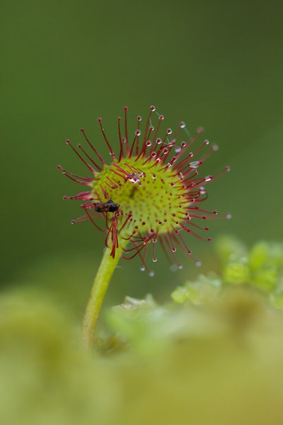
@geoffreygarcel  Flora
FloraRound-leaved sundew
It is a small carnivorous plant that lives in low-nutrient peat bogs. Don't worry, it only feeds on insects, which it attracts and digests using a viscous substance produced by the red bristles that cover its leaves. It is also known as " Rossolis or Sundew " because the substance sparkles when exposed to light. This species is fragile and protected, please do not touch it! This plant is used in homoeopathy for respiratory ailments (dry coughs).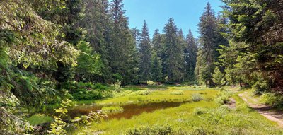
@asters FloraThe peat bog, an essential wetland
By definition, a peat bog is a wetland, covered by vegetation, where the specific ecological conditions have led to the formation of a soil containing a deposit of peat. Peat bogs act as climate change buffers, particularly through their ability to trap carbon. An active peatland traps an average of 733 kg of CO2 per hectare per year (Villa and Bernal, 2018). On a global scale, wetland soils store twice as much carbon as all the world's forests. Preserving these areas is therefore a real priority.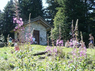
@hautgiffre-tourisme 
The Jacquicourt chapel, a heritage site with a turbulent history
The chapel was built in 1679. It was destroyed the same year because of disputes over the boundaries of the mountain pastures, and was rebuilt to its original form in 1986. The history of this chapel is closely linked to a 366-year dispute over the division of the communal boundaries between Les Gets, Taninges and Verchaix. Its reconstruction, thanks to the discovery of the ancient ruins by agents of the ONF, put an end to 6 centuries of conflict.
Description
From the Rossignols parking in Taninges, the Loëx plateau offers you a remarkable view of the Montagnes du Giffre. Go uphill to the right along a wide forest path that passes above the Les Têtes hamlet (1450 m), a former alpine village, and then follow "Les Miches" (1505 m). After approximately 500 m, take the fairly steep forest path which starts off on your left, and go as far as the Veruy Chalet (1570 m). There is a lovely view of the Col de Joux Plane, the Pointe de Chamossière and La Bourgeoise. After the chalet, on your left, take the trail which transforms into a small path at the end of the journey, and leads quietly to the Jacquicourt Chapel. After the Chapel, the trail descends into the forest and finally meets a narrow road leading back to the starting point.
- Departure : Rossignols parking area, the Têtes ski piste in Taninges
- Arrival : Rossignols parking area, the Têtes ski piste in Taninges
- Towns crossed : Taninges and Verchaix
Altimetric profile
Sensitive areas
Along your trek, you will go through sensitive areas related to the presence of a specific species or environment. In these areas, an appropriate behaviour allows to contribute to their preservation. For detailed information, specific forms are accessible for each area.
- Impacted practices:
- Land
- Sensitivity periods:
- JanFebMarAprMay
- Contact:
- DDT 74
Recommandations
Access to the Jacquicourt chapel is forbidden from 1 January to 15 May and during snowy periods.
Transport
Access and parking
12km from Taninges. Follow the signs for Les Gets (D307) for 3km, then at "Vers le Mont'' hamlet turn right towards the Montagne de Loëx. At the Mouille Rosse junction, turn right and park at the start of the Têtes ski trail.
Parking :
Rossignols parking area, 74440 Taninges
Report a problem or an error
If you have found an error on this page or if you have noticed any problems during your hike, please report them to us here: