
Stroll around lac d'Armancette
Les Contamines-Montjoie
Stroll around lac d'Armancette
Easy
2h
4,8km
+414m
-414m
Embed this item to access it offline
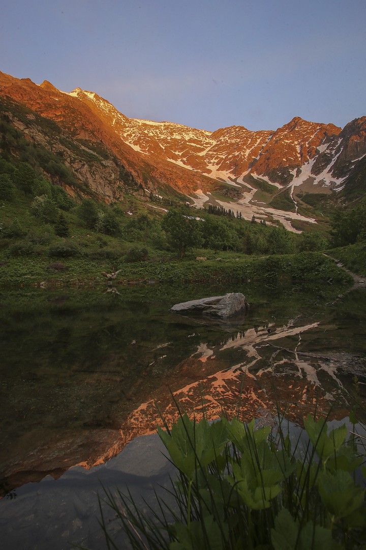
Most of this wonderful hike is through woodland and is not particularly challenging, with a panoramic view of the Dômes de Miage and Mont Joly from lac d'Armancette.
2 points of interest
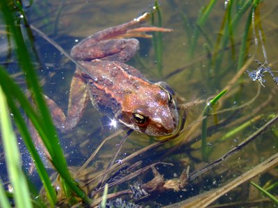
Grenouille rousse - Julien Heuret - CEN 74  Fauna
FaunaThe Grass Frog
This frog is a jack of all trades, master of all. It is the least water-reliant frog, it only returns to water during the breeding season or to hibernate. This super-frog can live at an altitude of up to 3000 meters! It is even said to be able to dive under the ice! But it is also one of the most widespread in Europe, living in different types of habitats, from parks and gardens or plain ponds to the highest mountain streams and lakes!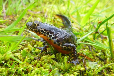
Triton alpestre - Julien Heuret - CEN 74 FaunaThe Alpine Newt
The Alpine newt is an amphibian that fears no cold! It can be found in Alpine lakes at altitudes of up to 2,500 metres. It can adapt to the often extreme temperatures by spreading its reproductive cycle over two years, or even by reproducing as a hatchling: this is known as "neoteny". It is a protected species, vulnerable to the threat of large fish. Fish stocking practices at high altitude lakes threaten the survival of these amphibians in these environments.
Description
From the La Frasse car park in Les Contamines-Montjoie, follow the forest track up to the junction. At the junction, take the forest track to the right, heading for "Lac d'Armancette". Turn left up the forest track. Continue straight on towards "Lac d'Armancette". Continue straight on towards "Lac d'Armancette". Take the left-hand path to "Lac d'Armancette". You will arrive at Lac d'Armancette. Return by the same route.
- Departure : Parking « la Frasse », Les Contamines-Montjoie
- Arrival : Parking la Frasse, les Contamines-Montjoie
- Towns crossed : Les Contamines-Montjoie
Altimetric profile
Sensitive areas
Along your trek, you will go through sensitive areas related to the presence of a specific species or environment. In these areas, an appropriate behaviour allows to contribute to their preservation. For detailed information, specific forms are accessible for each area.
- Impacted practices:
- Aerial, , Land, Vertical
- Contact:
- Asters - Conservatoire d'espaces naturels de Haute-Savoie
contact@cen-haute-savoie.org
Black grouse - winter
- Impacted practices:
- , Land
- Sensitivity periods:
- JanFebMarAprDec
- Contact:
Black grouse - winter
- Impacted practices:
- , Land
- Sensitivity periods:
- JanFebMarAprDec
- Contact:
- Asters - Conservatoire d'espaces naturels de Haute Savoie
Christelle BAKHACHE : 06 49 99 99 48
christelle.bakhache@cen-haute-savoie.org
Recommandations
Always exercise caution and plan ahead when hiking. Asters, CEN 74 cannot be held responsible for any accident or incident that may occur on this trail.
Information desks

Chef-lieu, 74170 LES CONTAMINES MONTJOIE
18 Route de Notre Dame de la Gorge, 74170 Les Contamines-Montjoie
Access and parking
Drive to the village of Les Contamines-Montjoie. In the centre of the village, take the road on the left that leads to the hamlet of La Frasse. Continue as far as the end of the road and then park in the car park of the same name.
Parking :
Parking la Frasse
Report a problem or an error
If you have found an error on this page or if you have noticed any problems during your hike, please report them to us here: