
Tré la Tête Glacier, return by the gorge
Les Contamines-Montjoie
Tré la Tête Glacier, return by the gorge
Medium
6h
13,3km
+963m
-963m
Embed this item to access it offline
From the forest to the edge of the glacier, this hike runs through varied environments which will reveal different aspects of the highest nature reserve in France.
Attachment
- Downloadpdf
glacier-de-tre-la-tete-retour-par-la-gorge
Credit: Points d'intérêts du parcours - Asters-CEN74
9 points of interest
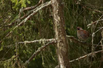
Gélinotte des bois_ Glacier Tré la Tête - Geoffrey Garcel - CEN 74  Fauna
FaunaThe Hazel Grouse
It is the smallest and most discreet of the mountain Galliformes species. Being an exclusively forest-dwelling spieces, it is much less well-known than the Lyre Grouse or the Rock Ptarmigan! Yet it is also important from a biological and scientific point of view: it is an environmental change indicator species. It's quite picky in its needs for vegetation and variety of tree species. Degraded and badly managed forests jeopardise its survival, which is one of the main causes of the species' decline.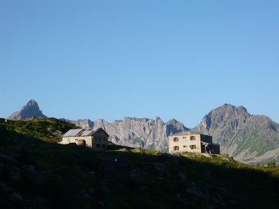
Refuge de Tré la Tête_ Glacier de Tré la Tête - Geoffrey Garcel - CEN 74  Refuge
Tré-la-Tête refuge
This refuge, situated at an altitude of 1970 m, has a history spanning over a century. Founded in 1907 to accommodate the pioneers of mountaineering, it is now a meeting place for all mountain enthusiasts. Whether you're a mountaineering enthusiast, a hiker on a day trip or a touring mountaineer, this is where your paths may cross. Conveniently located, it offers breathtaking views of the surrounding peaks as well as of the village 900 m below!
Surveillance de la réserve naturelle _Glacier de Tré la Tête - Geoffrey Garcel - CEN 74 
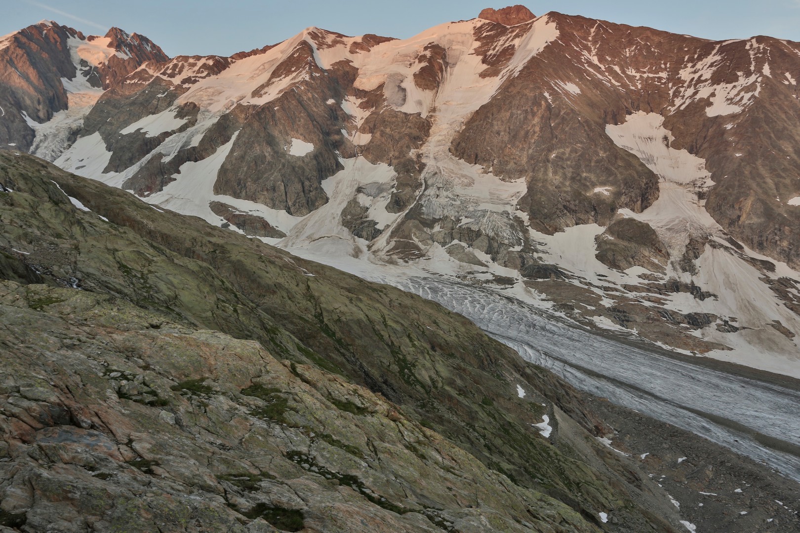
A glacier and humans
The Tré-la-Tête glacier is a mountaineering paradise. It is bordered by the legendary peaks of the Mont-Blanc massif, such as the Dômes de Miage and the Aiguille Nord de Tré-la-Tête, the highest point in the Nature Reserve at 3,892m. It is the crossing point for a number of regular and ski-mountaineering routes. Since the end of the nineteenth century, it has played an important role in the evolution of mountaineering.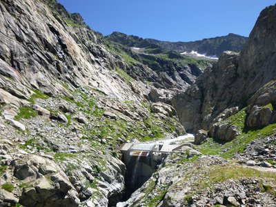
Prise d'eau - CEN 74 World's first under-glacier water supply
In 1939, Max Waeber, an engineer, secured a world's first under-glacier water source. The captured water is still used to irrigate an artificial lake (Lac de la Girotte, in the Beaufortin region) across ten kilometres of underground tunnels, for the purposes of hydropower generation. In 2011, the Nature Reserve, in partnership with EDF, carried out a programme to dismantle the industrial infrastructure linked to the creation of this water supply (sleeping quarters and cable cars).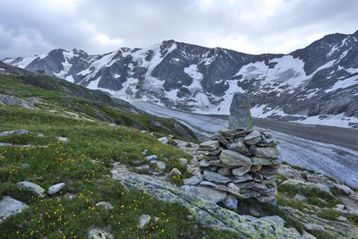
Vue sur le glacier _ Glacier de Tré la Tête - Geoffrey Garcel - CEN 74 
Tré-la-tête glacier
This glacier, the name of which means " over the head ", is the fourth largest in France! It is being studied in relation to climate change. Its condition has been monitored by the Nature Reserve since 2014, assessing the volume of ice gained or lost. This is known as mass balance. It is 8 km long, and its tongue of ice runs from the Infranchissable pass on the Italian border at an altitude of 3,300 m, right up to the place where you are standing!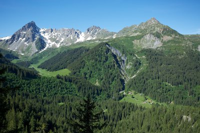
Vue depuis le belvédère de Combe noire - Geoffrey Garcel - CEN 74  Panorama
The Combe noire viewpoint
Make the most of this scenic viewpoint to catch your breath. But be careful, this place is unsafe as the rock is slippery! You overlook the forest and the village of "Combe noire". The name comes from the forest that is almost exclusively covered in dark spruce. From this stunning vantage point, you can see the Rollaz mountain pastures which are part of the GR footpath. From left to right, you can see the Roches rouges, the Roches franches, the Aiguilles de la Pennaz, the Col du Bonhomme, the Rocher du Bonhomme and finally the Tête Nord des Fours.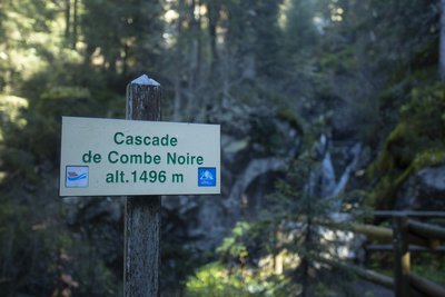
Cascade de Combe noire - Geoffrey Garcel - CEN 74  Geology
Combe noire waterfall
When you stop at this bridge, you can feel the fresh spray from the Combe Noire waterfall and just imagine that the Tré-la-Tête glacier arrived here in 1870! Since then, the glacier has melted a few hundred metres, but its presence can still be felt through the raging river, which has formed impressive sculptures known as "potholes of giants" as it erodes the rock in a thunderous racket!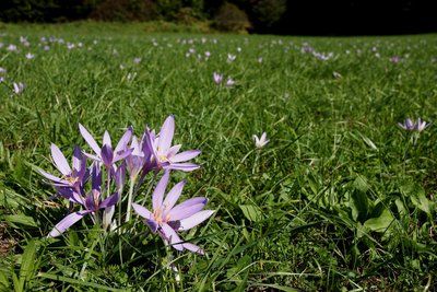
Colchique des Alpes - Julien Heuret - CEN 74  Flora
FloraThe Alpine Autumn Crocus
It's the end of summer... This is the time of year when the Alpine Autumn Crocus blossoms. Its name comes from Colchis in Greece, home to infamous poisoner Medea. This plant contains a highly toxic alkaloid: colchicine. According to the alchemists, this substance, when used in very small doses, could be used to treat rheumatism and episodes of gout.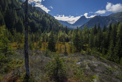
Tourbières de la Rosière - Geoffrey Garcel - CEN 74 FloraRosière boglands
On your left are the Rosière boglands, but be careful to only admire them while walking along the path, as they are fragile environments and hidden treasures of biodiversity! Tracing its origins from the Ice Age, this boggy area is the result of a glacier erosion which caused water to stagnate. This is the kingdom of carnivorous plants such as the Alpine cattail or the round-leaved sundew...
Description
Leave the car park in Contamines-Montjoie and follow the paved road along the edge of the forest. At the junction, take the path on your right signposted "Refuge de Tré-la-Tête". Turn left onto the footpath signposted "Tré-la-Tête par les plans". At the crossroads, follow the Claudius Bernard path towards the refuge. At the refuge, take the left-hand path to the Glacier de Tré-la-Tête. You have arrived. Use the same path to return to the refuge. At the fork in the path, take the left-hand path down. Turn left and cross the bridge opposite the waterfall. Turn right and head back down towards Notre-Dame de la Gorge. Continue straight ahead on the path alongside the stream. Continue straight ahead. The path ends here. Go back up along the paved road to find the car park 150m further down.
- Departure : Parking « Tré la Tête », les Contamines Montjoie
- Arrival : Parking Tré la Tête, les Contamines Montjoie
- Towns crossed : Les Contamines-Montjoie
Altimetric profile
Sensitive areas
Along your trek, you will go through sensitive areas related to the presence of a specific species or environment. In these areas, an appropriate behaviour allows to contribute to their preservation. For detailed information, specific forms are accessible for each area.
- Impacted practices:
- Aerial, , Land, Vertical
- Contact:
- Asters - Conservatoire d'espaces naturels de Haute-Savoie
contact@cen-haute-savoie.org
Black grouse - winter
- Impacted practices:
- , Land
- Sensitivity periods:
- JanFebMarAprDec
- Contact:
Black grouse - winter
- Impacted practices:
- , Land
- Sensitivity periods:
- JanFebMarAprDec
- Contact:
Recommandations
This itinerary runs through a nature reserve, please consult the regulations.
Transport
Reach Contamines-Monjoie and at the exit of the village, cross the bridge over the Armancette torrent and follow the signs until the Tré-la-Tête car park. The parking is located on the left of the road just before the town exit sign.
Access and parking
Head for Les Contamines-Monjoie and as you leave the village, cross the bridge over the Armancette stream and follow the signs to the Tré-la-Tête car park. The car park is on the left of the road immediately before the village exit sign.
Parking :
Parking Tré la tête
Report a problem or an error
If you have found an error on this page or if you have noticed any problems during your hike, please report them to us here: