
Plateau des Prés by la Balme
Les Contamines-Montjoie
Plateau des Prés by la Balme
Easy
4h
11,5km
+780m
-780m
Embed this item to access it offline
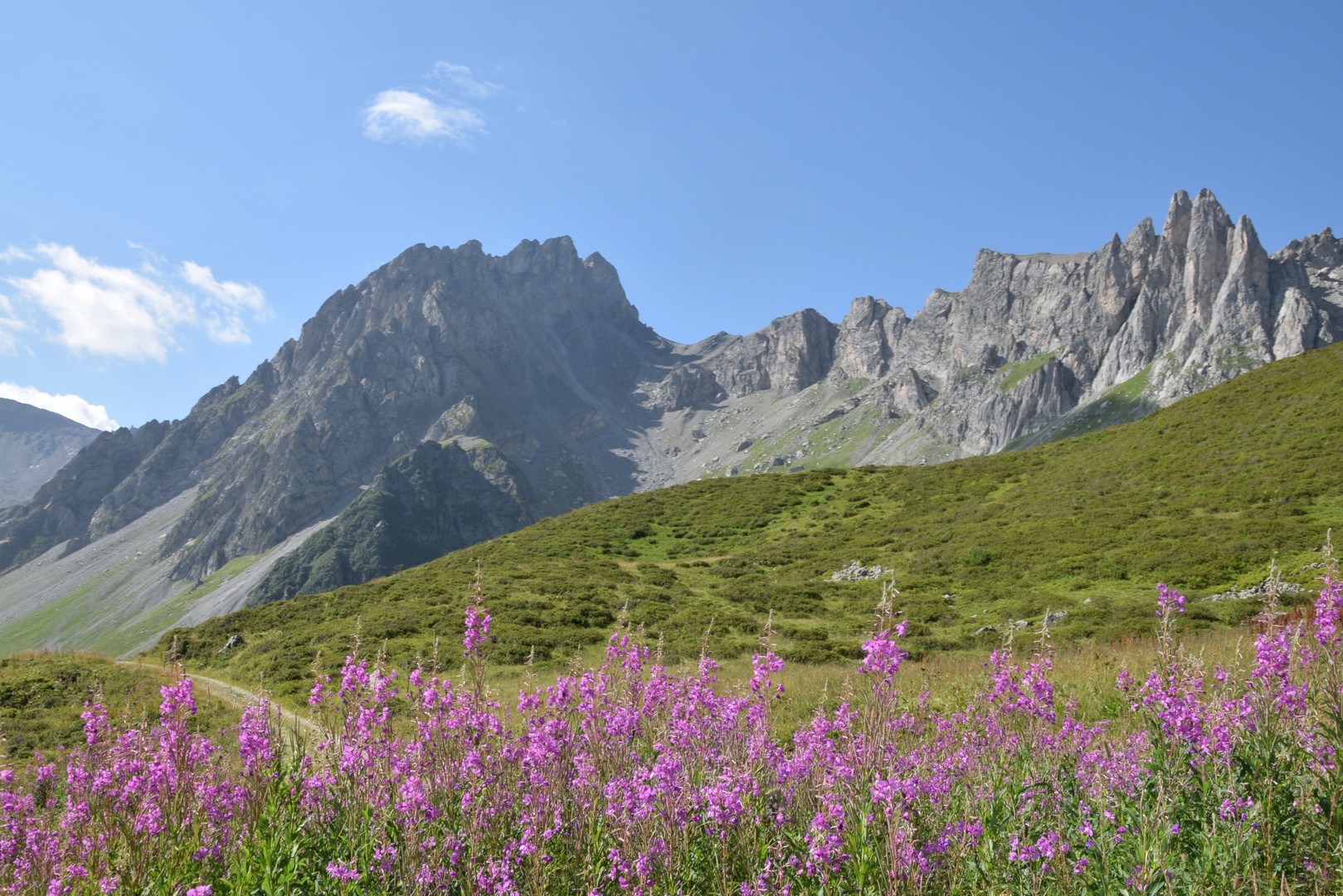
Set between mountain forests and alpine pastures, the view of the Mont Blanc massif awaits you.
15 points of interest
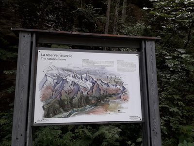
Panneau 13 - La réserve naturelle - CEN 74 
The nature reserve
A few steps away from the true entrance to the nature reserve, a panel presenting the issues of this protected and regulated natural space.
La voie romaine - Geoffrey Garcel - CEN 74 The Roman roads
More than just a tourist attraction, the Roman roads were one of the main routes used to cross the Alps in ancient times! Before the Roman invasion, the Ceutrones, a Celtic tribe who farmed livestock, inhabited the Val-Montjoie. To make cheese, they used salt mined at Moutiers via the Col du Bonhomme. They were involved in building roads to Italy. These roads were taken over by the Romans when they invaded the Alps. Take a look at the Rochassets pass: it was carved out of the rock to allow chariots to pass through!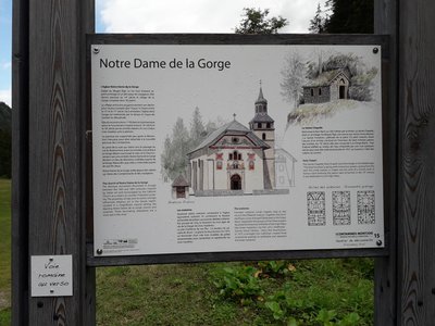
Panneau 15 - Notre Dame de la Gorge - CEN 74 Notre Dame de la Gorge
Find out everything you need to know about the history of the Notre Dame de la Gorge church, so that you can make the most of your visit later on.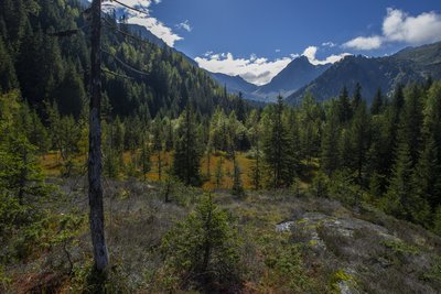
Tourbières de la Rosière - Geoffrey Garcel - CEN 74  Flora
FloraRosière boglands
On your left are the Rosière boglands, but be careful to only admire them while walking along the path, as they are fragile environments and hidden treasures of biodiversity! Tracing its origins from the Ice Age, this boggy area is the result of a glacier erosion which caused water to stagnate. This is the kingdom of carnivorous plants such as the Alpine cattail or the round-leaved sundew...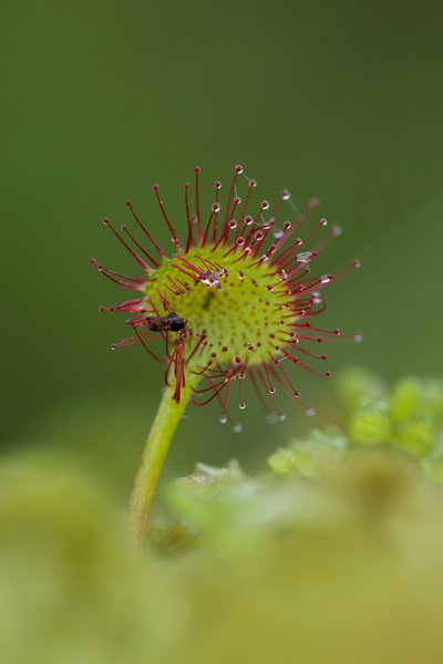
Insecte pris au piège d'une Drosera - Geoffrey Garcel - CEN 74 FloraThe round-leaf Sundew
It is a small carnivorous plant that lives in low-nutrient peat bogs. Don't worry, it only feeds on insects, which it attracts and digests using a viscous substance produced by the red bristles that cover its leaves. It is also known as " Rossolis or Sundew " because the substance sparkles when exposed to light. This species is fragile and protected, please do not touch it!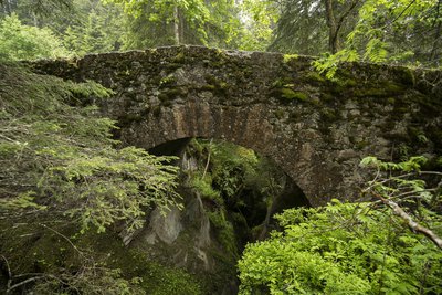
Pont romain - Geoffrey Garcel - CEN 74  Small patrimony
The Roman bridge
Also known as the "Téna Bridge", this structure dates back to Roman times! It is located on the strategic route used at that time to reach the Tarentaise valley and Italy from Les Contamines. This route, which has since become the famous long-distance GR5 hiking trail, is a popular tourist attraction. The bridge overlooks the gorges of Bont nant. Marvel at the pools of water that the waterstream has sculpted over the years!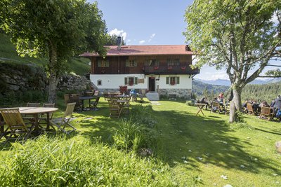
Refuge de Nant Borrant - Geoffrey Garcel - CEN 74  Refuge
The mountain refuge of Nant Borrant
This classic mountain refuge dates back to the 1800s. In 1842, the municipality of Les Contamines gave permission to build an inn here. It was known as the " Mountain Hotel " until 1976. With the development of the " Mont Blanc Tour " long-distance hiking trail, it became a refuge. However, ever since its creation, it has always been in the hands of the same family! It is open from June to the end of September. The Nant Borrant refuge is at the gateway to the nature reserve that begins just beyond the stream...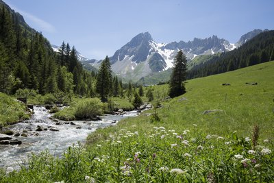
Alpage de la Rollaz - Geoffrey Garcel - CEN 74 
The mountain pasture
Alpine pastures are a landscape that have been shaped by humans since prehistoric times, during the Neolithic period, when livestock farming was first practised. Had it not been for the grazing of domestic animals at this altitude, the area would have been occupied by a few species of bush accompanied by few animal species. The mountain pasture is a rare example where human activity generates a biodiversity of animal and plant species that is more prolific than what would be produced by the natural evolution of the environment. Many species of plants, birds, invertebrates, mammals, etc. can be found here.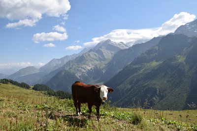
Vache de race Abondance - Geoffrey Garcel - CEN 74 Cow mountains
How can you tell which breeds of mountain cow can be found here? The Abondance breed originates from the village of the same name in the Chablais region of Haute-Savoie. It can be recognised by its distinctive mahogany coat and white head and belly. The 'Herens' cow comes from Valais in Switzerland. They are bulkier, with a single-coloured coat that is often black, sometimes dark red or chestnut. Its provocative, aggressive behaviour is used in the traditional "battle of the queens" in the 3 countries around Mont Blanc. But rest assured, no animals are harmed in such contests!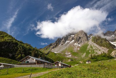
Geoffrey Garcel - CEN 74 RefugeThe mountain refuge of la Balme
Situated at the foot of the Aiguilles de la Pennaz (2668 m) as part of the Mont-Blanc tour, this refuge has a strong heritage of family tradition. Three generations have welcomed hikers here. This former farmhouse is surrounded by mountain pastures that are still cultivated by mountain farmers. Just look at the height of the roof and little will be left to imagination; during winter, the only thing sticking out of the snow is the chimney! This refuge is open from June to September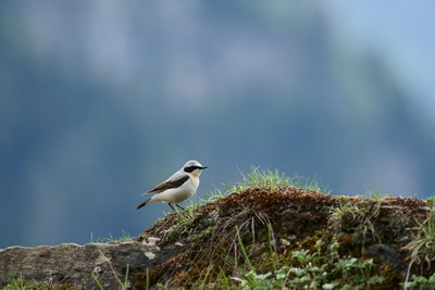
Mâle Traquet motteux - Julien Heuret - CEN 74  Fauna
FaunaThe Northern Wheatear
Have you seen Zorro with his black blindfold?! The male Northern Wheatear is a sparrow-sized passerine bird. However, this 25g lightweight is a long-distance migrant. Although it comes to nest in the mountains in summer, in search of insects such as flies, locusts and other grasshoppers, which are abundant in the alpine meadows, it spends the winter much further south, in the savannahs of tropical Africa, from Mauritania to Tanzania!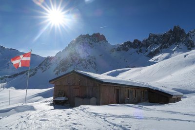
@GeoffreyGarcel 
Les Pres Refuge
The new Les Prés Refuge was built at an altitude of 1935m at the foot of the Aiguille de la Cicle (2552m), ideally situated in the heart of the nature reserve and right next to the hiking trails. This former mountain pasture farmhouse was restored in 2020 at the initiative of the Compagnie des Guides de Saint-Gervais-Contamines. This refuge is one of the few to be manned for more than 7 months of the year, including winter.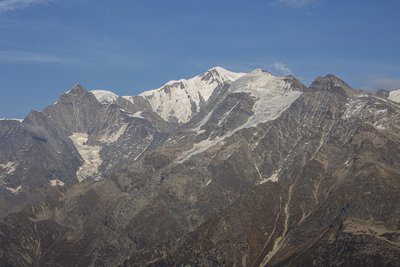
Panorama du massif du Mont Blanc - Geoffrey Garcel - CEN 74  Panorama
Mont-Blanc massif panorama
From here, you can see Mont-Blanc, the highest peak in Europe (4810 m), absolutely towering over the whole massif! Admire the view of the other peaks: the Aiguille de Bionassay (4052 m), the Dômes de Miage (3633 m) and the Aiguille Nord de Tré la Tête (3892 m), the highest point in the nature reserve. From this point, you can marvel at one of the parts of the reserve, which features various protected natural environments, situated in an area with over 2800m of variating altitude starting at the forest level.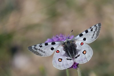
Grand apollon - Benoit Maubé - CEN 74 FaunaAs handsome as Apollo
This butterfly is a Rhopalocera, i.e. a common butterfly. It can be found in the mountains, in open environments with a certain amount of vegetation, its caterpillar tending to prefer orpins or houseleeks, while as an adult it feasts on the nectar of thistles and other knapweeds. It's beautiful... like a deity, but please just look at it, because it's an endangered species, protected both in France and worldwide!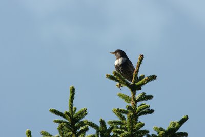
Merle à plastron perché - Julien Heuret - CEN 74 FaunaThe Ring Ouzel
As its name suggests, the ring ouzel is similar in size to the blackbird and belongs to the same genus according to the classification of living organisms. It is a mountain species, found only in the Alps. It nests in the "combat zone", i.e. the transition zone between the subalpine (forest) and alpine (grassland) levels, where there are fewer trees that are reminiscent of bonsai trees with their stunted silhouettes. The Ring Ouzel can be recognised by the white flap on its chest.
Description
From the Notre-Dame de la Gorge car park in Les Contamines-Montjoie : Cross the footbridge over the stream to join the itinerary. Stay on the main route which goes upstream on your right. Stay on the GR and take the Roman road that stretches out in front of you. Stay on the itinerary and cross the Roman bridge. At the crossroads, take the right-hand path onto the carriageway. At the crossroads, stay on the main track heading downhill. At the "chalet des prés", turn right onto the path leading downhill towards "Notre-Dame de la Gorge". Turn left to descend via the same trail that you've used for ascent.
- Departure : Parking « Notre Dame de la Gorge », Les Contamines-Montjoie
- Arrival : Parking Notre Dame de la Gorge, les Contamines Montjoie
- Towns crossed : Les Contamines-Montjoie
Altimetric profile
Sensitive areas
Along your trek, you will go through sensitive areas related to the presence of a specific species or environment. In these areas, an appropriate behaviour allows to contribute to their preservation. For detailed information, specific forms are accessible for each area.
- Impacted practices:
- Aerial, , Land, Vertical
- Contact:
- Asters - Conservatoire d'espaces naturels de Haute-Savoie
contact@cen-haute-savoie.org
Black grouse - winter
- Impacted practices:
- , Land
- Sensitivity periods:
- JanFebMarAprDec
- Contact:
Black grouse - winter
- Impacted practices:
- , Land
- Sensitivity periods:
- JanFebMarAprDec
- Contact:
Recommandations
Always exercise caution and plan ahead when hiking. Asters, CEN 74 cannot be held responsible for any accident or incident that may occur on this trail.
Transport
Bus shuttle service from Les Contamines (late June to early September).
Access and parking
Reach Les Contamines-Montjoie (74170). Drive through the village and stay on the Route de Notre-Dame de la Gorge (D902) for 2 kilometres until the road ends at the large Notre-Dame de la Gorge car park on your right.
Parking :
Parking Notre Dame de la Gorge
Report a problem or an error
If you have found an error on this page or if you have noticed any problems during your hike, please report them to us here: