
Mont Lachat, land given back to nature
Saint-Gervais-les-Bains
Mont Lachat, land given back to nature
Easy
1h45
3,9km
+324m
-321m
Embed this item to access it offline
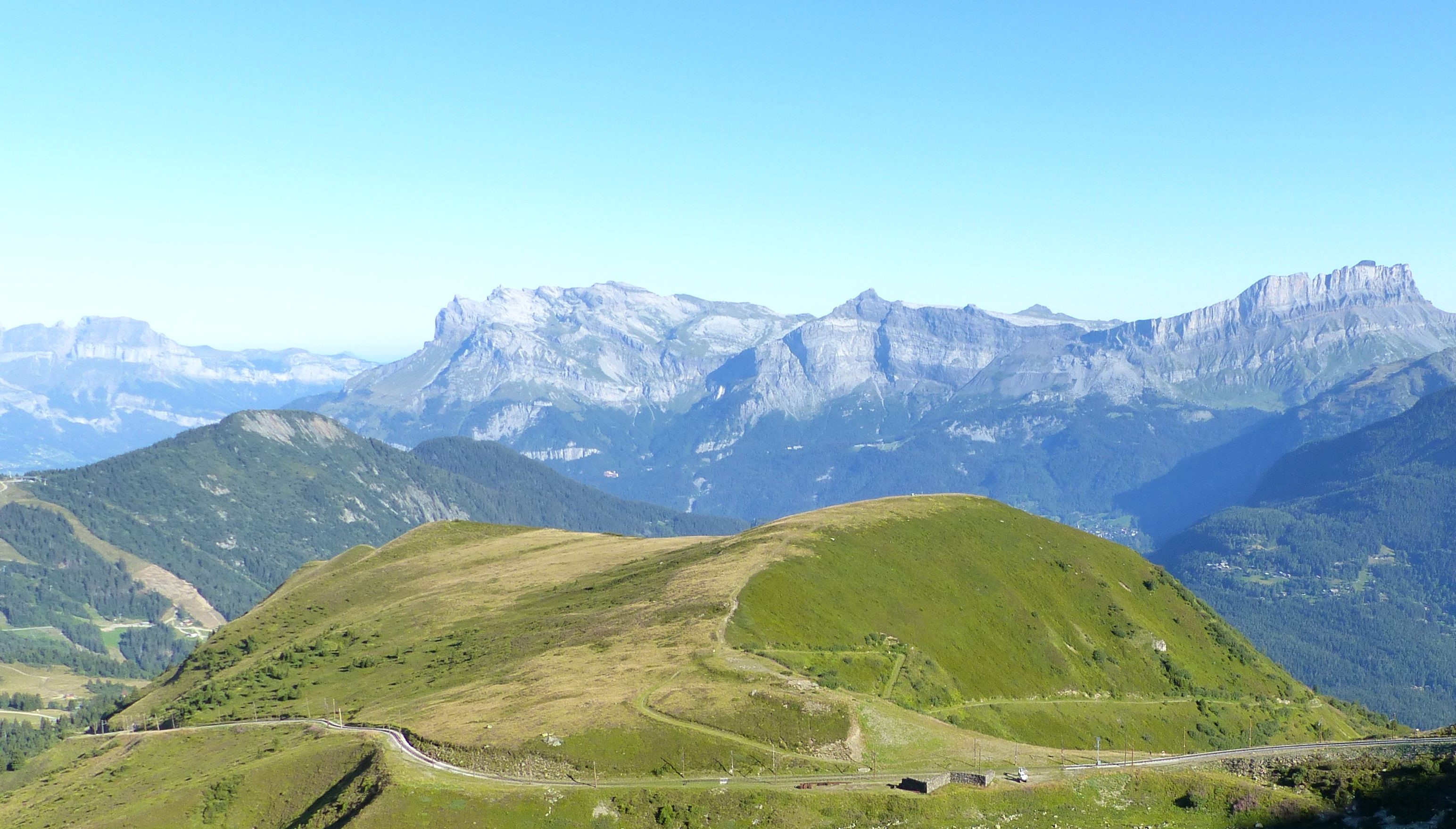
From clear forest to alpine meadows, this loop explores Mont Lachat and its diversity of environments. A hike full of history, with the old wind tunnel (blown glass factory) that was once located at the Mont Lachat mountain pass and has been dismantled since. This site is a preserved natural area with free access and information for visitors.
Attachment
- Downloadpdf
le-mont-lachat-espace-rendu-a-la-nature
Credit: Points d'intérêts du parcours - Asters-CEN74
11 points of interest
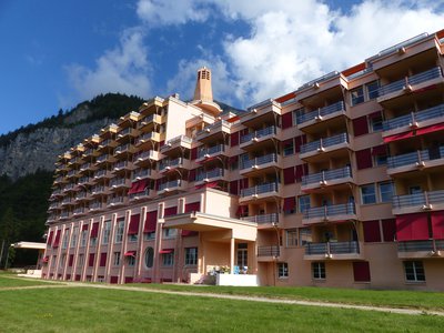
Sanatorium Martel de Janville à Passy, visible depuis le mont Lachat. - Lucie Rousselot - Asters CEN74 
Sanatoria on the Plateau d'Assy
What's that pink building perched on the other side of the valley? It's a former sanatorium, a treatment centre for tuberculosis. Because the mountain air and sunshine were thought to help cure respiratory diseases, the Plateau d'Assy was chosen at the beginning of the 20th century as the site for several of these sanatoria. South-facing, high up, and isolated from residential areas, they enjoyed a worldwide reputation.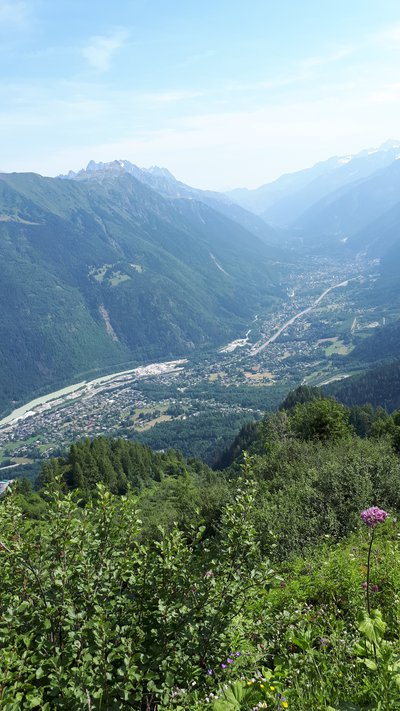
Vue sur la vallée de Chamonix creusée par les glaciers - Bluenne Bogaert - Asters CEN74 
Chamonix glacier valley
This U-shaped valley was carved out over 10,000 years ago by glaciers that extended as far as Lyon! All glaciers move forward by deforming and sliding under their own weight: the front of the glacier melts with the warmer temperatures of the valley, while the back is rejuvenated by the compacting of the snow at higher altitudes. These gigantic currents of ice, which are invisible to the naked eye, have carved out and eroded the valley where the town of Chamonix now stands.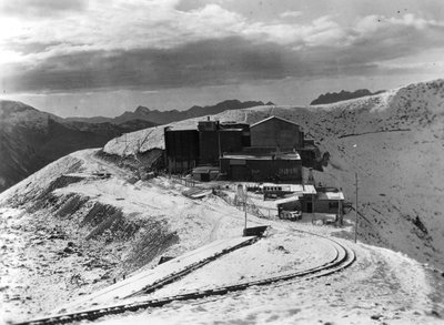
La soufflerie du mont Lachat, construite en 1937 à 2100m d'altitude - ONERA  Small patrimony
Mont Lachat wind tunnel
A wind tunnel was built on the Mont Lachat pass in 1937 for the purpose of testing aircraft engines in extreme conditions (wind and cold). After being used for a variety of purposes, the site became an industrial wasteland. In 2015, thanks to a large volume of funding, the site was restored and renaturated. This was an ambitious project, thanks in no small part to the use of low emission transportation of labourers, demolition equipment and waste by the Mont Blanc Tramway.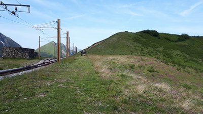
Effet du piétinement sur la reprise de la végétation au col du mont Lachat renaturé. - Bluenne Bogaert - Asters CEN74 Small patrimonyOne of a kind renaturation project
Once the buildings had been dismantled, the soil left bare as a result of these actions was reseeded with a mixture of local seeds (grasses, flowering plants, etc.): pioneer species that contribute to the formation of a substrate and therefore the growth of other species. All in all, around 5,000 m² have been restored! This renaturation project represents an unprecedented scientific experiment.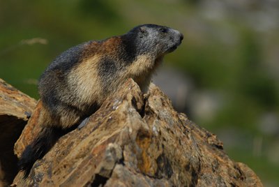
La marmotte des Alpes - Frank Miramand - Asters CEN74  Fauna
FaunaThe marmot, armed for life in the mountains
Underneath its cuddly exterior, the Marmot is a warrior adapted to the harsh conditions of the mountains. When the summer season arrives, its mission is clear: eat as much as possible to build up fat reserves for the winter. To survive hibernation, it needs to bulk up from 3 kg to 7 kg. No worries though, it's equipped for survival: a burly frame, nimble, claw-like paws for grasping food (plants, earthworms and insects) and sharp teeth for chopping and nibbling.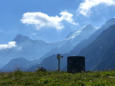
@LucieRousselot  Peak
PeakMountaineering and excess visitation
The Col du Mont Lachat is located on the standard route for the ascent to Mont Blanc, the highest peak in Western Europe. This mountaineering route requires special equipment. Between 15,000 and 20,000 people attempt it every year. This large number of visitors is bound to have an impact on this fragile environment: disturbance of wildlife, trampling, and anti-social behaviour (littering, etc.).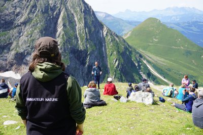
Animation mise en place dans le cadre de l'Espace Naturel Sensible du mont Lachat. - Anne-Laurence Mazenq - Asters CEN74  Flora
FloraEspace Naturel Sensible (ENS), a protected area
You are entering a Protected Natural Area (Espace Naturel Sensible - ENS). This is an area recognised for its natural heritage (fauna, flora, landscape) but which is threatened or vulnerable by urbanisation or human activities. The Mont Lachat ENS has been the site of ambitious restoration work. It is also part of the Mont-Blanc World Heritage Site, and is part of a broader initiative led by the Conseil Départemental to preserve the region's heritage and promote public awareness.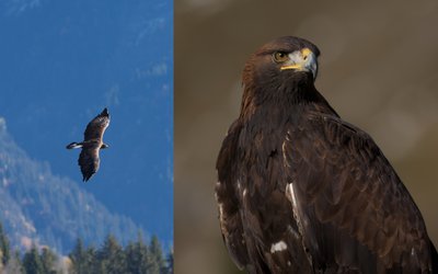
L'aigle royal - Geoffrey Garcel - Asters CEN74 FaunaThe Golden Eagle, a true symbol
A majestic bird, very useful for the regulation of rodent populations by consuming them, it has always fascinated humans as much as it has been feared. It has often been chosen as a symbol of power, as shown by the numerous coats of arms, the flags of current or former states (Napoleonic Empire, Germany, etc.).
It is also a source of inspiration for artists, of admiration, even of worship in different civilizations.
However, it has long been persecuted because it was considered to be "harmful". Nowadays, it is protected, like all raptors in France.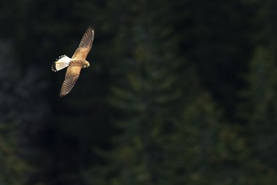
Faucon crécerelle en vol. - Laurent Theophile - Asters CEN74 FaunaThe common Kestrel
This small daytime bird of prey belongs to the Falconidae family, named for its scythe-shaped wings. Its long, pointed wings enable it to fly quickly and with great agility. The Kestrel can be found anywhere from the seaside to the mountains, as long as its prey (small rodents, amphibians and other insects) is found in abundance.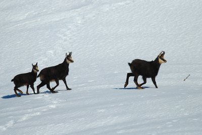
Chamois marchant sur la neige. - Frank Miramand - Asters CEN74 FaunaChamois behaviours
They are more likely to be found in forests during the winter, and roam alpine meadows in the summer: this is their seasonal altitudinal migration. In the event of an attack, it adopts the same escape strategy as its predators (wolves, lynx, eagles for young goats): it flees at full speed downhill! This requires a lot of energy, which it needs to survive the cold and scarcity of food in winter, or to reproduce. So if you come across one, give it time to move away peacefully.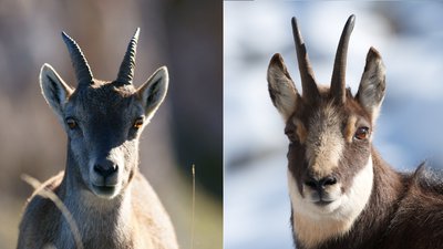
Bouquetin femelles (gauche) et chamois (droite) - Julien Heuret et Geoffrey Garcel - Asters CEN74 FaunaIs it a Chamois or an Ibex?
With a heart twice as big as ours and blood containing three times more red blood cells, the Chamois is a true athlete able to climb within 5 minutes what a trained human would do in an hour! The Alpine Chamois can be recognised by its hook-shaped horns and, most notably, its two dark stripes running from its eyes to its muzzle (the rest of its head is lighter). Be careful not to mistake it for the female Ibex: the latter has an almost uniform coloration, even on the head! As for the male Ibex, its long, ridged horns that curve backwards easily distinguish it from the Chamois.
Description
- On the Bellevue plateau, go behind the La Chalette restaurant and continue to the right behind it. Continue along this dirt track, which gradually gets steeper, to the crest of Mont Lachat, then to the summit near the viewpoint indicator.
- Begin the descent to the right of the orientation table to join the footpath running alongside the tracks.
- At the crossroads, turn left down the path away from the railway. Follow this path along the slopes of Mont Lachat until you reach the starting point at Bellevue.
- Departure : Tram station BELLEVUE, line TRAMWAY du Mont-Blanc
- Arrival : Bellevue, Saint-Gervais
- Towns crossed : Saint-Gervais-les-Bains
Altimetric profile
Recommandations
Warning: this route is not dangerous, but it can be quite challenging for some people because of its steep passages and proximity to the chasm ( with guard rails). Not suitable for people with a strong fear of heights.
Access and parking
The best way to get there is via the BELLEVUE stop on the Mont-Blanc tramway.
Second best way: Les Houches-Bellevue cable car
Second best way: Les Houches-Bellevue cable car
Parking :
Bellevue, Saint-Gervais
More information
Report a problem or an error
If you have found an error on this page or if you have noticed any problems during your hike, please report them to us here: