
The Brévent mountain
Les Houches
The Brévent mountain
Hard
6h30
8,8km
+1537m
-9m
Embed this item to access it offline
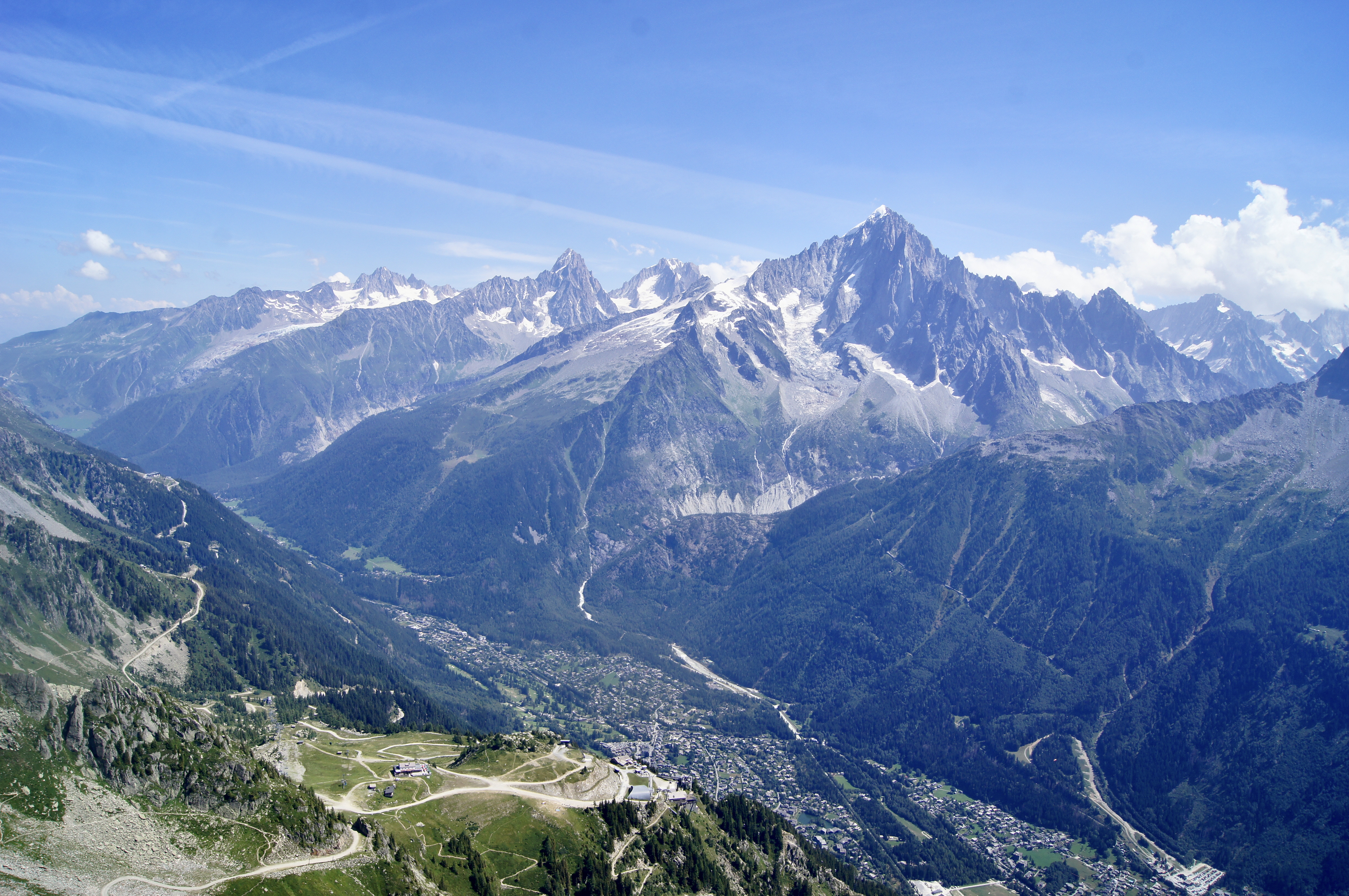
As we walk along the magnificent metamorphic rocks at the Aiguilles Rouges foot, we enjoy a breathtaking view of the Mont-Blanc massif and its retreating glaciers.
5 points of interest
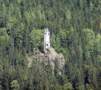
Statut Christ Roi - @XWeinzar  Small patrimony
The statue of Christ the King
In the 1930s, Abbot Claude Marie Delassiat decided to erect a statue of Christ in the commune of Les Houches as a tribute to Pope Pius XI (Achille Ratti by his non-religious surname), author of the encyclical on Christ the King and a prolific mountaineer. With the encouragement of the Vatican, Abbot Delassiat raised the money for his project through public fundraising campaigns, and the statue was unveiled on 19 August 1934 for World Peace, under the patronage of Abbot Claude-Marie Delassiat. The statue is situated at an altitude of 1,200 metres, is 25 metres tall and weighs 500 tonnes (made of reinforced concrete). Inside the statue, which is now no longer open to the public, there is a chapel in the distinctive Art Deco style, an altar decorated with 3 bas-reliefs, 2 angels and 4 statues, the Virgin of Peace, the Virgin Mary, a bust of Pius XI and St Joseph made by sculptor C. Serraz (who specialised in religious sculpture and designed the statue in collaboration with architect Féveille).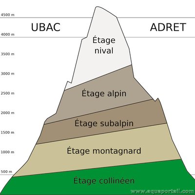
Zonage de montage : les différents étages - @aquaportail 
Stratification of vegetation
Les Houches is the lowest point of the Tour du Mont-Blanc. The hills (at an altitude of 1100 m) are packed to the brim with villages and deciduous forests. The forests are now standing where previously cultivated fields once stood. In the mountains, temperature, humidity, duration of snow cover and light levels vary with altitude. The average temperature drops by 0.6°C per 100 m of ascent, and rainfall increases up to 2,500 m and decreases past that. These altitudinal variations in living conditions are at the origin of a phenomenon known as stratification. Here’s a breakdown of various areas as can be seen from the valley to the summits: first comes the hilly area with its fields and broadleaf forests, then the mountain and sub-alpine zones mostly covered by spruce trees around Mont Blanc. As forest thins out, it gives way to heathland, which forms the subalpine zone, up to the snow line where rock and snow predominate.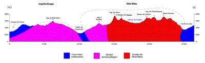
Coupe géologique - @DanielleDECROUEZ  Geology
The rising of the Alps
The Alps are the product of a continental collision that took place some 40 million years ago: the Alpine collision. The Mont-Blanc / Aiguilles Rouges massif area is an exceptional place where the effects of two separate tectonic plate collisions over 250 million years apart are visible, and where erosion (mostly glacial), shapes the craggy landscapes before our very eyes. This collision on the Mont-Blanc massif caused a vertical landmass shift that resulted in literal “rising” of the mountains imbuing them with various rocks ranging from gneiss to granite.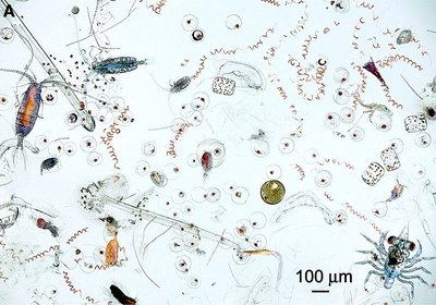
Zooplancton et phytoplancton - @Asters-CEN74  Lake
LakeLac du Brévent: high altitude lake
Brévent Lake (The Lac du Brévent), which you can see below, is a high-altitude lake in the Aiguilles Rouges nature reserve. This small lake (2.4 hectares) was formed when a glacier eroded the rocks. The lake is unusual in that it is small and shallow (less than 20m in depth), with little water circulation between the surface and the bottom of the lake. It is completely covered in ice for more than 8 months of the year, and its waters are lacking in nutrients. It is not ideal for the development of abundant flora and fauna. Fish were introduced to the lake in 1906, but none of the species (except the minnow) thrived there naturally. This practice was stopped in 2010 to protect other living organisms, namely zooplankton and phytoplankton. This lake is a ‘sentinel’ for understanding the global changes and human impact on the nature.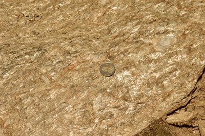
Itinéraires géologique - @DahUlm GeologyGlitter of Brevent summit
We couldn't complete this ascent of the Brevent without introducing you to the mineral that covers this part of the Aiguilles Rouges massif with its gorgeous glitter: muscovite (common white mica (white). Micas are silicate minerals structured in layers. Both white and black micas have a metallic lustre, which is what gives the scenery its ‘disco ball’ effect. It is a mineral rich in aluminium. These are ancient granite stones that were deformed 400 million years ago, under conditions of very high temperature and pressure. They are known as ‘metamorphic rocks’. They formed the ancient bedrock of the mountain chain that predates the Alps.
Description
From the Parking de la Gare (train station car park) at Les Houches :
Take the Chemin des Eaux Rousses.
After a few hairpin bends, walk along the Merlet park and then fork right onto the path heading towards ‘Aiguillette des Houches et Refuge Bellachat’. This path climbs up the slopes through forests and alpine pastures, cutting through a few gullies which may be occasionally dangerous; use metal ramps.
From the Bellachat refuge, follow the path above the refuge, heading north, up fairly rugged slopes filled with minerals. The path is stony but well signposted...
After a few hairpin bends, you reach the summit of Le Brévent. The panorama view is magnificent on all sides: The Mont Blanc itself and also the Aiguilles Rouges, the Fiz, Platé, and further on the Aravis and Beaufortain massifs...
You can return by the same route or take the Brévent cable car and then the train.
- Departure : Place de la gare, Les Houches
- Arrival : Brévent
- Towns crossed : Les Houches and Chamonix-Mont-Blanc
Altimetric profile
Sensitive areas
Along your trek, you will go through sensitive areas related to the presence of a specific species or environment. In these areas, an appropriate behaviour allows to contribute to their preservation. For detailed information, specific forms are accessible for each area.
- Impacted practices:
- Aerial, , Land, Vertical
- Contact:
- Asters - Conservatoire d'espaces naturels de Haute Savoie
contact@cen-haute-savoie.org
Recommandations
Please note that the route is more difficult when you go up in the valley towards Le Brévent. Always be careful and plan ahead when hiking. Asters CEN-74 cannot be held responsible for any accident or inconvenience that may occur on this route. Check the weather conditions before setting off. Mountain Rescue contact details: call 112
Report a problem or an error
If you have found an error on this page or if you have noticed any problems during your hike, please report them to us here: