La Balme - col des Fours : discovering alpine geology
Les Contamines-Montjoie
La Balme - col des Fours : discovering alpine geology
Medium
4h
12,5km
+987m
-980m
Embed this item to access it offline
Undoubtedly the most beautiful leg of the tour with untouched and geologically rich environments. Can you recognise a glacial rock bar or a thrust sheet in these landscapes?
6 points of interest
Nappe de Roselette - @DahUlm  Geology
The Roselette nappe
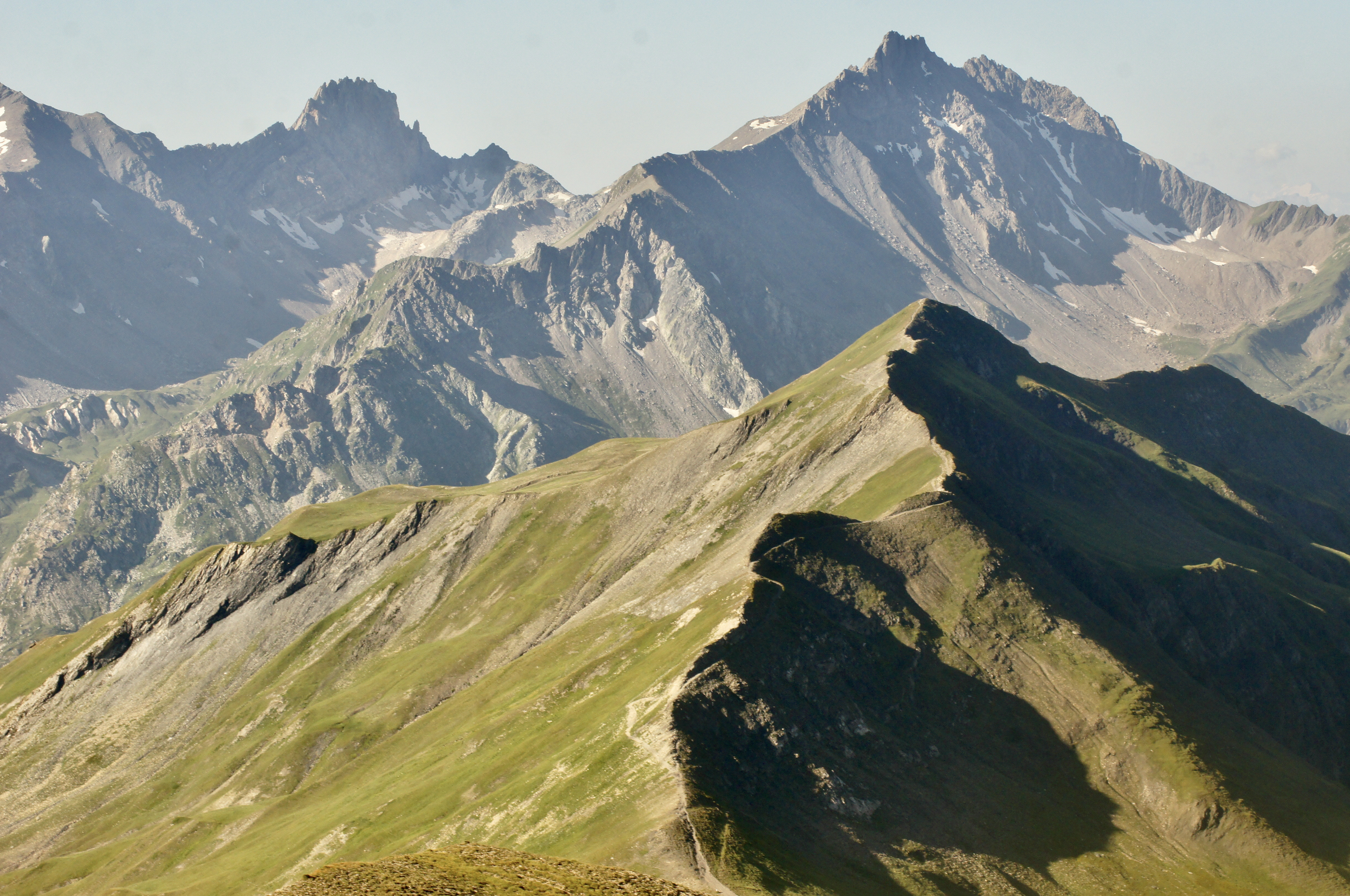
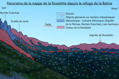
Upstream of the Balme refuge, when looking to the west, you can see two different types of rock: - sedimentary rocks (Aiguille de la Pennaz and Roches Franches, light grey folded tithonic limestone) - basement rocks (gneiss, dark in colour and jagged in appearance). These two formations are part of the Roselette nappe, which was swept 8km from the south-east to the north-west some 30-15 million years ago. In geology, a nappe is a layer of land that has been displaced by tectonic forces over a considerable distance and has since overlaid another layer. By analysing the landscape, you can see the motions and forces of the tectonic plates.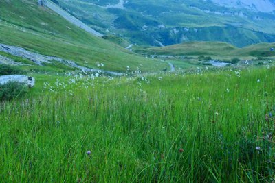
Zone humide et linaigrettes - @DahUlm GeologyThe Plan Jovet peat bog
The path crosses a wetland area, where you can recognise the small feathery flower heads of cottongrass (pictured), horsetail and lycopods (lycopodiaceaes). Peat bogs reflect the natural evolution of a mountain lake: at high altitudes, organic matter decomposes very slowly and gradually fills up the lake. A hygrophilous flora which is specific to the humid environment develops here. Although peat bogs represent only 3% of the Earth's surface, they contain around 25% of the world's organic soil carbon. Thanks to ancient pollens, peat bogs also enable scientists to find information about life in the massif as it was thousands of years ago. To protect this ecosystem, stay on the marked trails!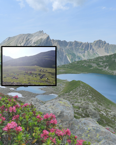
Une réalité pas toujours rêvée - @Asters-CEN74  Lake
LakeBivouacking and swimming prohibited
A familiar sight in the steep ravines and slopes of the mid-mountain regions of the Alps and Corsica, Alnus alnobetula has the unique ability to bend under snow and even rockslides without breaking. It grows rapidly, taking just a few decades to transform a meadow into a dense forest. This prevents the seeds of other trees from sprouting, thus blocking the natural evolution of the Alpine ecosystem. This plant improves soil quality: Green alder retains nitrogen in the soil and also strengthens the soil that is vulnerable to landslides thanks to its robust roots. However, Green Alder is also considered to be a threat to ecosystems: it colonises environments lacking other plant species by overgrowing fields that could be suitable for grazing and spreads nitrogen, nitrate and nitrous oxide, which in large quantities is harmful to the environment.

Excessive trail frequentation, the actions of Asters CEN74
Asters-CEN74 and its partners of the Gebiodiv project (PITEM Biodiv'alp) spent two days restoring this very popular hiking section of the GR5 on the Tour du Mont-Blanc trail.
How to restore a degraded trail?
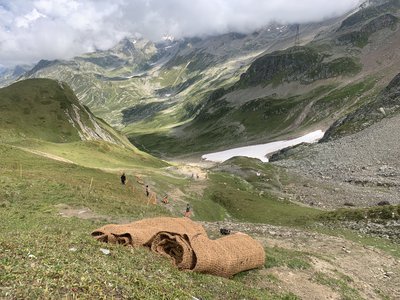
The team collected local seeds, raked the areas to be revegetated and installed geotextile membranes (made of coconut fiber) to increase seed growth.
Help us make this work last! Going off the hiking trails destroys the surrounding flora. Like scars, the new paths will encourage soil erosion causing the disappearance of vegetation. Be carefull! Stay on the main trail!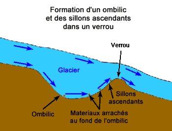
Verrou glaciaire - @ BrunoPisano GeologyRiegel (Glacial rock bar )
As you move away from the alpine pastures of La Balme towards the Col du Bonhomme, the valley narrows, but does not quite completely close in. This topographical change is called a “riegel”, or glacial rock bar: it is an area that has withstood glacial erosion more effectively. Here, the glacier's downward slide has been slowed due to obstructions. Sometimes, this process led to overdeepening of an area above the riegel. Similarly, a glacier which slides down off a side of a mountain will form a bend when it reaches the valley floor. Boulders brought in by the glacier are deposited on this bend, forming a lateral moraine that can block the flow of water. This is how many high-altitude lakes are formed!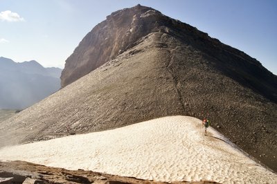
Etage nival - @DahUlm  Flora
FloraSnow line
This alternate route via the Col du Four gives us a good opportunity to cross the snow line. On the way up to the Col du Four, you might have noticed that the vegetation is becoming increasingly patchy. The first permanent snow line is around 2700m above ground, at the Col du Four, which marks the area where snow can be seen year-round. Although the vegetation is sparser, it still can be seen: mostly moss and lichen and also other plants such as androsaces, saxifragas and glacier buttercups (visible during the climb). The flora finds shelter from the wind and cold in the crevices of the rocks; some plants grow in the form of a cushion.
Description
From the Balme refuge, follow the path up to the Col du Bonhomme.
At the crossroads, turn right towards the Col du Bonhomme (the Lacs Jovet will be on your left).
At the Col du Bonhomme, continue towards the Col de la Croix du Bonhomme.
Turn left onto the Col des Fours alternative route.
The return journey is by the same route.
- Departure : Balme Refuge
- Arrival : Col des Fours
- Towns crossed : Les Contamines-Montjoie
Altimetric profile
Sensitive areas
Along your trek, you will go through sensitive areas related to the presence of a specific species or environment. In these areas, an appropriate behaviour allows to contribute to their preservation. For detailed information, specific forms are accessible for each area.
- Impacted practices:
- Aerial, , Land, Vertical
- Contact:
- Asters - Conservatoire d'espaces naturels de Haute-Savoie
contact@cen-haute-savoie.org
Black grouse - winter
- Impacted practices:
- , Land
- Sensitivity periods:
- JanFebMarAprDec
- Contact:
Black grouse - winter
- Impacted practices:
- , Land
- Sensitivity periods:
- JanFebMarAprDec
- Contact:
Recommandations
Bivouacking at The Jovet Lacs and Plan Jovet is prohibited from 1 July to 31 August. Swimming is prohibited for hikers and pets all year round. Depending on the time of year, you may encounter numerous névé areas (partially melted compacted snow), making certain sections potentially dangerous, even in summer. Always be careful and plan ahead when hiking. Asters CEN-74 cannot be held responsible for any accident or inconvenience that may occur on this route. Check the weather conditions before setting off. Mountain Rescue contact details: call 112. Respect the work of farmers, managers and owners Close all fences Bring back all rubbish Do not take shortcuts through meadows
More information
Report a problem or an error
If you have found an error on this page or if you have noticed any problems during your hike, please report them to us here: