
Tré la Tête Glacier by Combe noire Waterfall
Les Contamines-Montjoie
Tré la Tête Glacier by Combe noire Waterfall
Hard
6h
10,8km
+937m
-937m
Embed this item to access it offline
Between forests, streams, waterfalls, meadows and glaciers, this hike traverses a variety of environments and breathtaking views. Reward yourself for this walk with a breathtaking panorama at the end of it!
Attachment
- Downloadpdf
glacier-de-tre-la-tete-par-la-cascade-de-combe-noire
Credit: Points d'intérêts du parcours - Asters-CEN74
10 points of interest
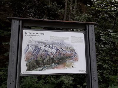
Panneau 13 - La réserve naturelle - CEN 74 
The nature reserve
A few steps away from the true entrance to the nature reserve, a panel presenting the issues of this protected and regulated natural space.
Tourbières de la Rosière - Geoffrey Garcel - CEN 74  Flora
FloraRosière boglands
On your left are the Rosière boglands, but be careful to only admire them while walking along the path, as they are fragile environments and hidden treasures of biodiversity! Tracing its origins from the Ice Age, this boggy area is the result of a glacier erosion which caused water to stagnate. This is the kingdom of carnivorous plants such as the Alpine cattail or the round-leaved sundew...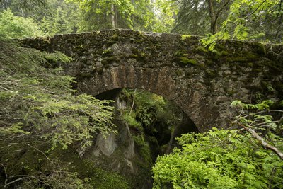
Pont romain - Geoffrey Garcel - CEN 74  Small patrimony
The Roman bridge
Also known as the "Téna Bridge", this structure dates back to Roman times! It is located on the strategic route used at that time to reach the Tarentaise valley and Italy from Les Contamines. This route, which has since become the famous long-distance GR5 hiking trail, is a popular tourist attraction. The bridge overlooks the gorges of Bont nant. Marvel at the pools of water that the waterstream has sculpted over the years!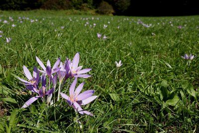
Colchique des Alpes - Julien Heuret - CEN 74 FloraThe Alpine Autumn Crocus
It's the end of summer... This is the time of year when the Alpine Autumn Crocus blossoms. Its name comes from Colchis in Greece, home to infamous poisoner Medea. This plant contains a highly toxic alkaloid: colchicine. According to the alchemists, this substance, when used in very small doses, could be used to treat rheumatism and episodes of gout.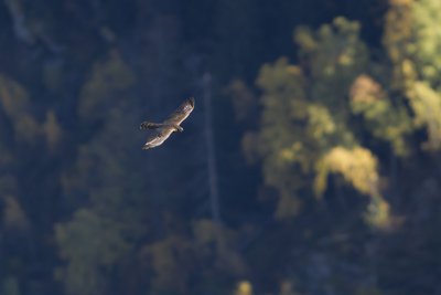
Epervier en vol - Geoffrey Garcel - CEN 74  Fauna
FaunaThe Sparrowhawk
Like a bolt of lightning, a silvery silhouette threaded its way silently between the branches, accompanied by the shrieks of tits and kinglets... What luck! You've just spotted a sparrowhawk! This small, daytime bird of prey is common but very secretive. It is the terror of passerines, an order that comprises most songbirds. The sparrowhawk is their executioner! It is a predator that plays on the element of surprise by flying as close to the ground as possible or hiding behind obstacles to surprise its prey.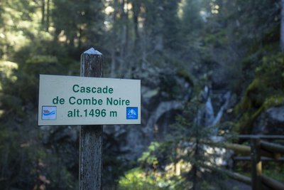
Cascade de Combe noire - Geoffrey Garcel - CEN 74  Geology
Combe noire waterfall
When you stop at this bridge, you can feel the fresh spray from the Combe Noire waterfall and just imagine that the Tré-la-Tête glacier arrived here in 1870! Since then, the glacier has melted a few hundred metres, but its presence can still be felt through the raging river, which has formed impressive sculptures known as "potholes of giants" as it erodes the rock in a thunderous racket!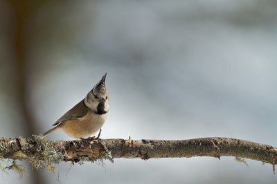
Mésange huppée - Geoffrey Garcel - CEN 74 FaunaThe Crested Tit
It is a small forest passerine that often lives in the company of its brethren, such as the Black-capped Chickadee or the Willow Tit, as they share the same habitats. Its presence is linked to that of old trees, either dead wood or ageing trees, also known as "senescent wood". It is particularly fond of coniferous forests (spruce, pine and fir). It is a lively little ball of energy, constantly on the move and recognisable by its crested tail. It feeds on small insects, larvae and spiders, as well as conifer seeds.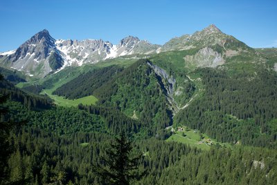
Vue depuis le belvédère de Combe noire - Geoffrey Garcel - CEN 74  Panorama
The Combe noire viewpoint
Make the most of this scenic viewpoint to catch your breath. But be careful, this place is unsafe as the rock is slippery! You overlook the forest and the village of "Combe noire". The name comes from the forest that is almost exclusively covered in dark spruce. From this stunning vantage point, you can see the Rollaz mountain pastures which are part of the GR footpath. From left to right, you can see the Roches rouges, the Roches franches, the Aiguilles de la Pennaz, the Col du Bonhomme, the Rocher du Bonhomme and finally the Tête Nord des Fours.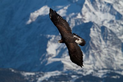
Aigle royal en vol - Geoffrey Garcel - CEN 74 FaunaThe Golden Eagle
It's a predator, armed for the hunt! Thanks to its large, wide wings, it glides high into the sky in search of prey. Its exceptional eyesight spots marmots (its favourite meal), hares, foxes or ptarmigan, and sometimes even young chamois or ibex! Its prominent eyebrow arch acts as a sun shield when it swoops down to snatch its prey. It is equipped with talons for grabbing and a powerful, hooked sharp beak for tearing flesh.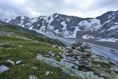
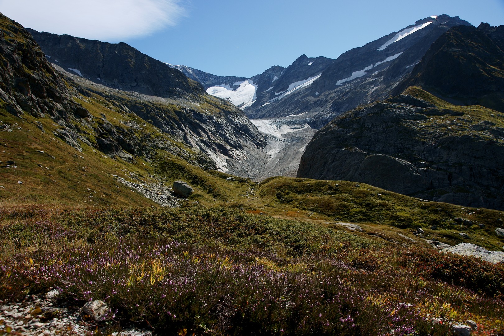
Vue sur le glacier _ Glacier de Tré la Tête - Geoffrey Garcel - CEN 74 
Tré-la-tête glacier
This glacier, the name of which means " over the head ", is the fourth largest in France! It is being studied in relation to climate change. Its condition has been monitored by the Nature Reserve since 2014, assessing the volume of ice gained or lost. This is known as mass balance. It is 8 km long, and its tongue of ice runs from the Infranchissable pass on the Italian border at an altitude of 3,300 m, right up to the place where you are standing!
Description
Departure from the Notre-Dame de la Gorge parking area in Les Contamines-Montjoie : Cross the footbridge over the stream to join the itinerary. Stay on the main route which goes up the stream Stay on the GR and take the Roman road that stretches out in front of you Stay on the itinerary and cross the "Pont romain" (Roman bridge) Turn left towards "la Laya" - "Tré la tête". Turn left to reach the Combe Noire waterfall At the end of the bridge opposite the waterfall, turn right towards "Tré la tête". At the refuge, turn right towards the "glacier de Tré la tête". You have now reached the "Tré la tête" glacier. The return journey is by the same route.
- Departure : Parking « Notre Dame de la Gorge », Les Contamines-Montjoie
- Arrival : Parking Notre Dame de la Gorge, les Contamines-Montjoie
- Towns crossed : Les Contamines-Montjoie
Altimetric profile
Sensitive areas
Along your trek, you will go through sensitive areas related to the presence of a specific species or environment. In these areas, an appropriate behaviour allows to contribute to their preservation. For detailed information, specific forms are accessible for each area.
- Impacted practices:
- Aerial, , Land, Vertical
- Contact:
- Asters - Conservatoire d'espaces naturels de Haute-Savoie
contact@cen-haute-savoie.org
Black grouse - winter
- Impacted practices:
- , Land
- Sensitivity periods:
- JanFebMarAprDec
- Contact:
Recommandations
Always exercise caution and plan ahead when hiking. Asters, CEN 74 cannot be held responsible for any accident or incident that may occur on this trail.
Transport
Bus shuttles depart from the village centre of Les Contamines-Montjoie (from late June to early September).
Access and parking
Reach Les Contamines-Montjoie (74170). Drive through the village and stay on the Route de Notre-Dame de la Gorge (D902) for 2 kilometres until the road ends at the large Notre-Dame de la Gorge car park on your right.
Parking :
Parking Notre Dame de la Gorge
Report a problem or an error
If you have found an error on this page or if you have noticed any problems during your hike, please report them to us here: