
From Le bout du Monde to Le Fond de la Combe
Sixt-Fer-à-Cheval
From Le bout du Monde to Le Fond de la Combe
Easy
3h
7,8km
+0m
0m
Embed this item to access it offline
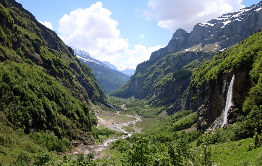
Following along the Giffre river, the trail crosses forests and meadows before reaching a spectacular view of an ancient glacial valley and its rugged cliffs.
Attachment
- Downloadpdf
fond-de-la-combe-depuis-le-bout-du-monde
Credit: Points d'intérêts du parcours - Asters-CEN74
8 points of interest
Un site sculpté par les éléments - Francesca Jeanparis - CEN74  Geology
A landscape sculpted by nature
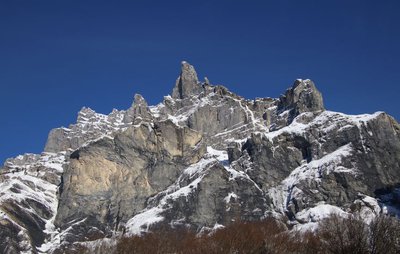
The formation of this impressive landscape is the result of the forces of nature. The rocks, which are of limestone origin, were formed in a marine environment over 200 million years ago. The tectonic movements that gave birth to the Alps then carefully folded the rocks to raise and form this massif, which was then exposed to erosion. Finally, the cirque at the bottom of the Combe was hollowed out and shaped by a glacier over 20,000 years ago. These gigantic limestone cliffs are just the visible part of the mountains that stretch higher up.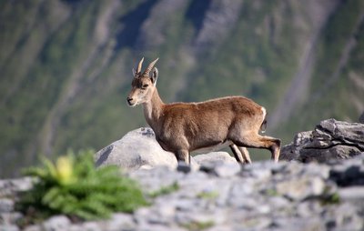
Un échantillon de la faune alpine - Francesca Jeanparis - CEN74  Fauna
FaunaA glimpse of Alpine wildlife
The Fond de la Combe, at around 1,000 m elevation, is surrounded by a number of gigantic mountains that exceed 2,500 m in elevation. This variation in altitudinal range creates a wide variety of natural environments, which are home to almost all the animal species found in the French Alps. The most well-known of these are the marmot, golden eagle, griffon vulture, bearded vulture, chamois and ibex. You can see the ibex from wherever you are: instead of looking for this talented tightrope walker in the meadows or forest, look for it on the cliff faces in front of you. All these species are easily visible to those who take the time to observe while keeping a low profile!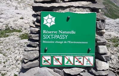
Vous êtes dans un espace protégé ! - Titouan Vaisy - CEN 74 
You are in a protected area!
This spot marks the entrance to the Sixt-Fer-à-Cheval/Passy National Nature Reserve. The reserve is managed by the Conservatoire d'Espaces Naturels de la Haute Savoie, which is responsible for managing, protecting, and developing this natural area. The reserve is open to the public and is very popular, which means that it is subject to regulations designed to protect species and habitats. Rangers are on hand to answer any questions you may have and to ensure that these regulations are respected.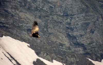
Les falaises, zones de refuge - Francesca Jeanparis - CEN74 FaunaBirds' hideout shelter zones on cliffs
Sunny rocky escarpments attract feathered species of all kinds for several reasons. Firstly, they create ascending air currents, which are very useful for large birds of prey to gain height and move around without wasting energy. Secondly, they provide refuge, nesting and feeding areas for many birds. In this protected area, these environments are reserved for them: disturbance in the wrong place at the wrong time by paragliders, drones or any other human activity during the breeding season could result in failure to reproduce for the birds.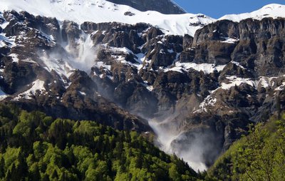
Nature toute-puissante - Francesca Jeanparis - CEN74 GeologyThe all-powerful nature
The knowledge we have acquired over the years means that we can now understand the natural hazards in our mountains. However, while some of them can be predicted, their scale and consequences still seem just as uncontrollable. Although the bottom of the valley appears to be flat and fairly wide, the slopes on either side of the valley are ideal for avalanches and rockfalls. The effects of these avalanches can be seen for much of the summer, with snow still present at the foot of the cliffs. Keep your distance, as the ice caves they form could collapse at any moment. In winter, a government order prohibits access to the site!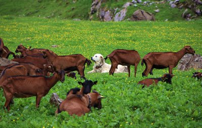
Chiens de protection des troupeaux - Francesca Jeanparis - CEN74 
Livestock guardian dogs
These are guardian dogs, so their use is permitted in nature reserves. They are there to defend sheep and lambs from attacks by large predators, such as wolves. Often large in size, these dogs, known as "molossoids", dedicate their lives to protecting the livestock to which they are deeply attached. When approaching the herd, it is important to remain aware of their attitude and to adapt to it, while following simple instructions: - Keep your distance from the herd (go around it if possible) - Call out loudly to the herds and dogs to avoid surprising them - Stay calm and avoid sudden movements, keep walking without running. Don't hesitate to speak softly to them so that they get used to you and accept your presence. - Avoid looking dogs in the eyes and try to ensure that you always have an object or an obstacle between you and the dog.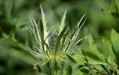
Diversité floristique - Francesca Jeanparis - CEN74  Flora
FloraFloral diversity
The great diversity of the area's natural environments has given rise to a rich floral variety: there are 942 species of plants, 63 of which are rare or protected. At a moderate altitude of around 1,000 m, this trail is rather unusual! it is home to species that normally can only be found at a higher altitude: this is due to the steepness of the slopes, where avalanches and floods bring in plants or seeds from higher up.
Témoins du passé - Conseil Départemental 74 Traces of the past
The first humans to settle here had a lot of courage. There were very few flat areas, forests covering the valley, devastating natural hazards, and a winter that lasted 6 months... As they settled here, they also adapted their techniques to the limitations of the land, particularly the slopes, and adopted a way of life dictated by the seasons. The architecture, landscapes and local traditions of the village reflect the way of life of bygone days.
Description
From the car park, head for the Plan des Lacs, an open area where the site's reception chalet is located. Take the trail into the forest and follow it in the direction of "Chalet de Prazon". Turn left and take the footbridge towards "Chalet de Prazon". Continue to the right of the Prazon refreshment bar and follow the river in the direction of "le Bout du Monde". When you reach "Bout du Monde", turn back along the same path as far as the Fond de la Combe footbridge. Cross the hanging footbridge to the other side of the valley and follow the path to the footbridge at the bottom of the valley. Turn right to cross the river again and return to the car park via the Giffrenant.
- Departure : Parking « Fer à Cheval »
- Arrival : Parking le Fer à Cheval
- Towns crossed : Sixt-Fer-à-Cheval
Sensitive areas
Along your trek, you will go through sensitive areas related to the presence of a specific species or environment. In these areas, an appropriate behaviour allows to contribute to their preservation. For detailed information, specific forms are accessible for each area.
- Impacted practices:
- Aerial, , Land, Vertical
- Contact:
- Asters - Conservatoire d'espaces naturels de Haute Savoie
contact@cen-haute-savoie.org
Recommandations
This trail runs through a nature reserve, please consult the regulations. Dogs are allowed on a leash as far as the Prazon refreshment bar. Limited access from November to June, depending on snow conditions, due to the high avalanche risk and the absence of footbridges. Bike access is regulated by municipal by-law (July-August).
Transport
Line 94 Cluses - Taninges - Samoens - Sixt Fer à Cheval Summer shuttle bus: no reservation required, price: 1 euro per person for the day ticket, 7 days a week in July and August
Access and parking
Reach the village of Sixt-Fer-à-Cheval. Go through the village by the main road and follow the signs for "Cirque du Fer-à-Cheval". The road passes through several small hamlets before reaching the paid car park.
Parking :
Parking Cirque du Fer-à-Cheval
Report a problem or an error
If you have found an error on this page or if you have noticed any problems during your hike, please report them to us here: