Les Houches - Les Contamines-Montjoie : discovering alpine geology
Les Houches
Les Houches - Les Contamines-Montjoie : discovering alpine geology
Medium
5h
16,9km
+1028m
-849m
Embed this item to access it offline
Undoubtedly the most beautiful leg of the tour with untouched and geologically rich environments. Can you recognise a glacial rock bar or a thrust sheet in these landscapes?
4 points of interest
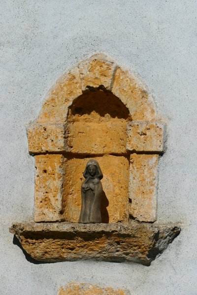
Chapelle de Bionnassay - @DahUlm 
Cargneules of the Bionnassay chapel
Have you noticed the rocks surrounding the doors, niches and windows of this chapel? These are cargneules (dolomite cavities with lime cement), easily recognisable by their orange colour and porous appearance. These rocks are often mineralised by pyrite, an iron sulphide. When pyrite decomposes, it forms deposits of sulphur and iron oxides, giving the cargneules its characteristic yellow-orange colour. In this region, cargneules are linked to the Triassic geological period, which also includes gypsum (white rocks formed in an area affected by water evaporation). Gypsum, which plays a key role in tectonic movements, contains water that can be released under pressure, facilitating the formation of cargneules near rifts.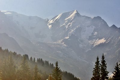
Glavier de Bionnassay - @DahUlm 
The Bionnassay glacier
You are now standing on Col de Voza. Look up at Mont Blanc and you'll see the Bionnassay glacier overlooking the valley below. This glacier obscures another, much smaller one: the Tête-Rousse glacier. Located on the right-hand side of the Bionnassay, it cannot be seen from the valley. It was first discovered on the night of 11 to 12 July 1892, when a pocket of water ruptured at the front of the glacier. Several million cubic metres of water and ice tumbled down the mountain, devastating the villages below and the thermal baths of Saint-Gervais. 175 people died, swept away by torrential waters. In 2010, a new pocket was discovered and emptied between September and October of the same year.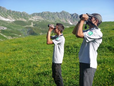
Gardes de la réserve naturelle des Contamines-Montjoie - @carolineGehant  Flora
FloraContamines-Montjoie National Nature Reserve
As you go up the Nant Borrant, you enter the Contamines-Montjoie Nature Reserve. Created in 1979, it stretches over 5,500 hectares from the village to the Aiguille de Tré-la-Tête (3,892 m). It stretches from the mountainous zones to snowy lines, and is home to a rich biodiversity. To enjoy and admire this wild and pristine nature for many years to come, we need to follow a few simple rules: - Picking a flower means destroying a plant. - The presence of dogs in the reserve disrupts the ecosystem: dogs can destroy broods and eggs, they transmit pathogens and cause stress to the wildlife. This nature reserve is one of the few where dogs are allowed on a lead, because this nature reserve features a hiking path. - This area can only be explored on foot; motor vehicles, and overflying such as paragliding, hang-gliding, helicopters, drones, etc. is prohibited at a height of less than 300 m from the ground. - let's collect our rubbish and take it back with us. - Bivouacking is forbidden at the Plan Jovet and the Lacs Jovets, but is permitted in the rest of the reserve. Camping is prohibited throughout the nature reserve. - Swimming is prohibited at the Lacs Jovets and the Plan Jovet - Stay on the main path to limit the risk of destroying plants that are as scarce as they are inconspicuous, and to make sure that the future generations of hikers will still be able to admire this beautiful natural site. Let's share our nature and behave responsibly!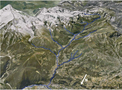
Le bon nant - IGN geoportail  Lake
LakeBon Nant
A nant is a term used to describe a mountain stream. The Bon Nant springs from the Contamines-Montjoie nature reserve at the Col du Bonhomme and flows into the Arve in Le Fayet some fifteen kilometres further down; it is one of the Arve’s largest tributaries. It forms the boundary between the Mont-Blanc and Beaufortain massifs and is used for hydroelectric power generation and fishing.
Description
Follow the white and red TMB (Mont-Blanc Tour) signs. From the station, cross the Arve and follow the road towards the village in the direction of the Col de Voza.
Pass under the tunnel
Follow the forest track up to the Col de Voza
Cross the tramway tracks and follow the track back down to the right towards Bionnassay
Cross the Gruvaz car park and exit towards Les Contamines-Montjoie.
- Departure : Place de la gare, Les Houches
- Arrival : Les Contamines-Montjoie
- Towns crossed : Les Houches, Saint-Gervais-les-Bains, and Les Contamines-Montjoie
Altimetric profile
Sensitive areas
Along your trek, you will go through sensitive areas related to the presence of a specific species or environment. In these areas, an appropriate behaviour allows to contribute to their preservation. For detailed information, specific forms are accessible for each area.
- Impacted practices:
- Aerial, , Land, Vertical
- Contact:
- Asters - Conservatoire d'espaces naturels de Haute-Savoie
contact@cen-haute-savoie.org
Recommandations
Always be careful and plan ahead when hiking. Asters CEN-74 cannot be held responsible for any accident or inconvenience that may occur on this route. Check the weather conditions before setting off. Mountain Rescue contact details: call 112
More information
Report a problem or an error
If you have found an error on this page or if you have noticed any problems during your hike, please report them to us here: