
Tête Nord des Fours
Les Contamines-Montjoie
Tête Nord des Fours
Very hard
10h
24,2km
+1651m
-1651m
Embed this item to access it offline
As you follow the slopes, you'll discover every floor of the mountain landscape. Appreciate the diversity of the nature reserve as it unfolds at greater altitudes.
Attachment
- Downloadpdf
tete-nord-des-fours
Credit: Points d'intérêts du parcours - Asters-CEN74
24 points of interest
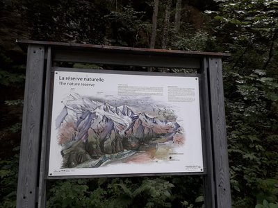
Panneau 13 - La réserve naturelle - CEN 74 
The nature reserve
A few steps away from the true entrance to the nature reserve, a panel presenting the issues of this protected and regulated natural space.
La voie romaine - Geoffrey Garcel - CEN 74 The Roman roads
More than just a tourist attraction, the Roman roads were one of the main routes used to cross the Alps in ancient times! Before the Roman invasion, the Ceutrones, a Celtic tribe who farmed livestock, inhabited the Val-Montjoie. To make cheese, they used salt mined at Moutiers via the Col du Bonhomme. They were involved in building roads to Italy. These roads were taken over by the Romans when they invaded the Alps. Take a look at the Rochassets pass: it was carved out of the rock to allow chariots to pass through!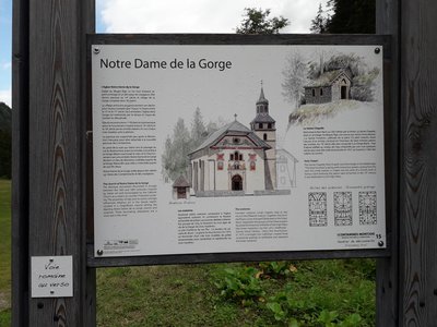
Panneau 15 - Notre Dame de la Gorge - CEN 74 Notre Dame de la Gorge
Find out everything you need to know about the history of the Notre Dame de la Gorge church, so that you can make the most of your visit later on.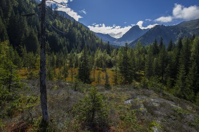
Tourbières de la Rosière - Geoffrey Garcel - CEN 74  Flora
FloraRosière boglands
On your left are the Rosière boglands, but be careful to only admire them while walking along the path, as they are fragile environments and hidden treasures of biodiversity! Tracing its origins from the Ice Age, this boggy area is the result of a glacier erosion which caused water to stagnate. This is the kingdom of carnivorous plants such as the Alpine cattail or the round-leaved sundew...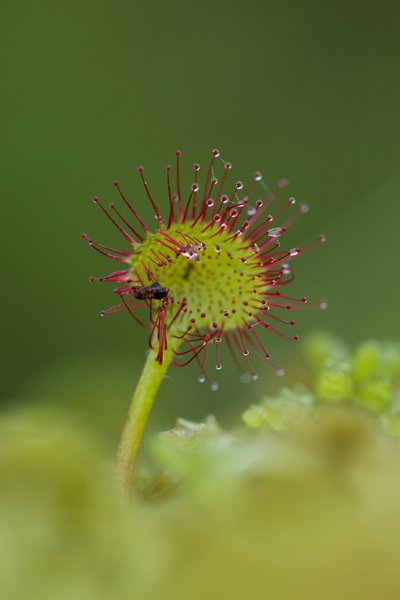
Insecte pris au piège d'une Drosera - Geoffrey Garcel - CEN 74 FloraThe round-leaf Sundew
It is a small carnivorous plant that lives in low-nutrient peat bogs. Don't worry, it only feeds on insects, which it attracts and digests using a viscous substance produced by the red bristles that cover its leaves. It is also known as " Rossolis or Sundew " because the substance sparkles when exposed to light. This species is fragile and protected, please do not touch it!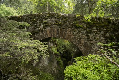
Pont romain - Geoffrey Garcel - CEN 74  Small patrimony
The Roman bridge
Also known as the "Téna Bridge", this structure dates back to Roman times! It is located on the strategic route used at that time to reach the Tarentaise valley and Italy from Les Contamines. This route, which has since become the famous long-distance GR5 hiking trail, is a popular tourist attraction. The bridge overlooks the gorges of Bont nant. Marvel at the pools of water that the waterstream has sculpted over the years!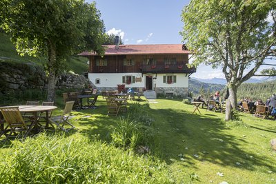
Refuge de Nant Borrant - Geoffrey Garcel - CEN 74  Refuge
The mountain refuge of Nant Borrant
This classic mountain refuge dates back to the 1800s. In 1842, the municipality of Les Contamines gave permission to build an inn here. It was known as the " Mountain Hotel " until 1976. With the development of the " Mont Blanc Tour " long-distance hiking trail, it became a refuge. However, ever since its creation, it has always been in the hands of the same family! It is open from June to the end of September. The Nant Borrant refuge is at the gateway to the nature reserve that begins just beyond the stream...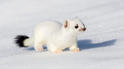
@LionelRoux  Fauna
FaunaThe Stoat, a mountain chameleon
White in winter and with brown backs and beige bellies in summer, stoats have black tail tips all year round. Often confused with the common weasel, the stoat differs in size. It is larger (17 to 33 cm) and has a two-coloured tail. A carnivore, its favourite prey are voles. Stoats are vivacious and playful. The Stoat often moves in leaps of up to 50 centimetres in height, covering great distances for its size of up to 15 km.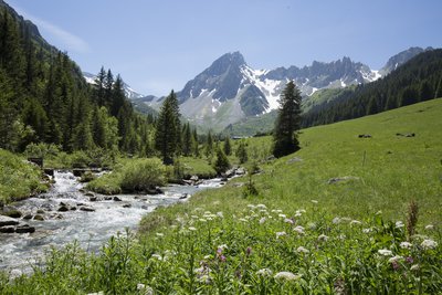
Alpage de la Rollaz - Geoffrey Garcel - CEN 74 
The mountain pasture
Alpine pastures are a landscape that have been shaped by humans since prehistoric times, during the Neolithic period, when livestock farming was first practised. Had it not been for the grazing of domestic animals at this altitude, the area would have been occupied by a few species of bush accompanied by few animal species. The mountain pasture is a rare example where human activity generates a biodiversity of animal and plant species that is more prolific than what would be produced by the natural evolution of the environment. Many species of plants, birds, invertebrates, mammals, etc. can be found here.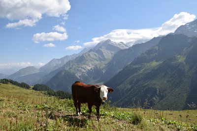
Vache de race Abondance - Geoffrey Garcel - CEN 74 Cow mountains
How can you tell which breeds of mountain cow can be found here? The Abondance breed originates from the village of the same name in the Chablais region of Haute-Savoie. It can be recognised by its distinctive mahogany coat and white head and belly. The 'Herens' cow comes from Valais in Switzerland. They are bulkier, with a single-coloured coat that is often black, sometimes dark red or chestnut. Its provocative, aggressive behaviour is used in the traditional "battle of the queens" in the 3 countries around Mont Blanc. But rest assured, no animals are harmed in such contests!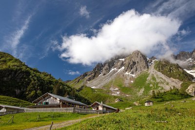
Geoffrey Garcel - CEN 74 RefugeThe mountain refuge of la Balme
Situated at the foot of the Aiguilles de la Pennaz (2668 m) as part of the Mont-Blanc tour, this refuge has a strong heritage of family tradition. Three generations have welcomed hikers here. This former farmhouse is surrounded by mountain pastures that are still cultivated by mountain farmers. Just look at the height of the roof and little will be left to imagination; during winter, the only thing sticking out of the snow is the chimney! This refuge is open from June to September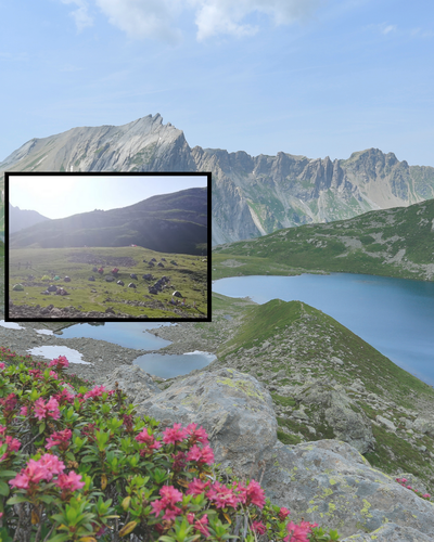
Une réalité pas toujours rêvée - @Asters-CEN74  Lake
LakeBivouacking and swimming prohibited
A familiar sight in the steep ravines and slopes of the mid-mountain regions of the Alps and Corsica, Alnus alnobetula has the unique ability to bend under snow and even rockslides without breaking. It grows rapidly, taking just a few decades to transform a meadow into a dense forest. This prevents the seeds of other trees from sprouting, thus blocking the natural evolution of the Alpine ecosystem. This plant improves soil quality: Green alder retains nitrogen in the soil and also strengthens the soil that is vulnerable to landslides thanks to its robust roots. However, Green Alder is also considered to be a threat to ecosystems: it colonises environments lacking other plant species by overgrowing fields that could be suitable for grazing and spreads nitrogen, nitrate and nitrous oxide, which in large quantities is harmful to the environment.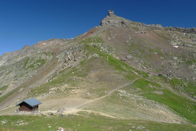
Col et rocher du Bonhomme - Julien Heuret - CEN 74  Geology
The Bonhomme rock
Over the "col du Bonhomme" mountain pass, located in the southern part of the reserve,the Aiguilles de la Pennaz mountains rise to the west and Bonhomme Rock to the east. Bonhomme Rock got its name because of its likeness to the shape of a man's face..... You must have seen it, right?
Inconnu Resistance at the top
In June 1940, when the French army was losing the war against Hitler's Nazi forces and his Fascist ally Mussolini, the pass where you are standing was the scene of one of the first victories of the free world. A detachment of around thirty men under the command of Lieutenant Bulle defeated the Italians at an altitude of more than 2,600 m and a temperature of -10°, using machine-gun fire from the Italians' rear flank, after having rappelled down the cliff. This success allowed them to recapture Tête de l'Enclave!
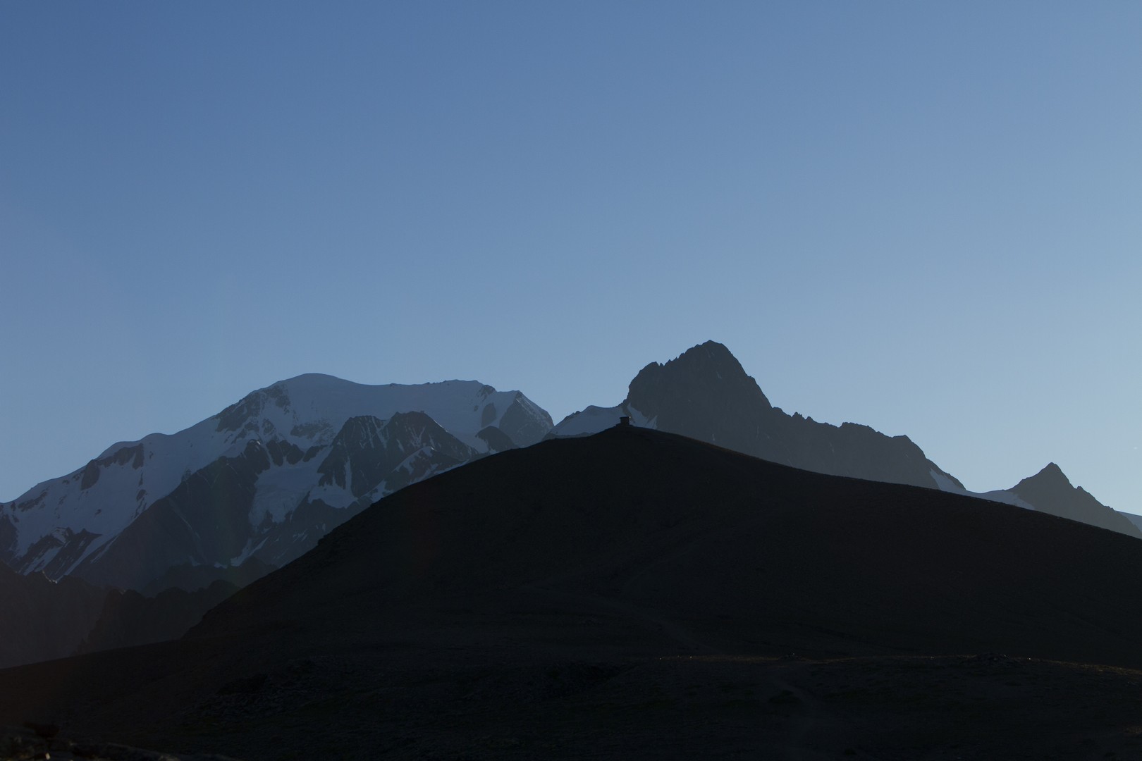
Vue sur la Tête Nord des Fours - Geoffrey Garcel - CEN 74  Panorama
Tête Nord des Fours
From this summit of 2665 metres, admire the breathtaking view of the Mont Blanc Massif, the Haut-Giffre, the Aravis and the Beaufortin. A 360-degree panorama awaits you, but wait, there's more. As a bonus, you can even see the Matterhorn mount in Switzerland under clear skies and in the beautiful autumn sunlight! Take advantage of the orientation table to find out the names of the surrounding peaks... In front of you, the Nature Reserve unfurls its 5,500 hectares of protected areas: forests, mountain pastures, cliffs, high-altitude lakes, glaciers... and almost 3,000 metres of vertical drop.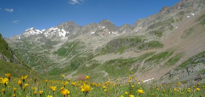
La réserve depuis le Col du Bonhomme - Julien Heuret - CEN 74 Col du Bonhomme
At an altitude of 2329 metres, the Col du Bonhomme links the Val Montjoie to the Beaufortin, and Haute-Savoie to Savoie. It is one of the passes crossed by the GR 5 trail, the Tour du Mont Blanc and the Tour du Beaufortin. Thanks to its strategic location, this pass has been a crossing point for Romans, peddlers, crystal smiths, and livestock merchants throughout history... In 1860, when Savoie and the Comté de Nice were annexed by France, a free trade zone was established over a large part of northern Savoie, with the pass as one of its boundaries.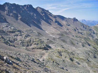
Glaciers noirs - Jean-Baptiste BOSSON - CEN 74 
Black glaciers
At first glance, the slope overlooking Plan Jovet towards the Fours ridge to the south is nothing but rock. However, glaciers buried under a layer of sediment have recently been discovered here! These glaciers are known as "black glaciers", in contrast to "white glaciers". The layer that covers them protects them from the sun, meaning that they are now melting slower than the others.
Geoffrey Garcel Flora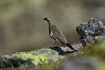
Lagopède en plumage été - Geoffrey Garcel - CEN 74 FaunaThe Rock Ptarmigan
This species, gifted with mimicry, is able to transform its plumage between summer and winter seasons in order to visually become part of its environment. Its name, which means "hare's foot", refers to its foot digits covered by the fuzz in winter! It is one of the most endangered bird species in the Alps. Every year the nature reserves of Haute-Savoie carry out population monitoring in order to study their evolution. The results are shared with the "Observatoire des Galliformes de Montagne".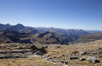
Grés singuliers - Geoffrey Garcel - CEN 74 Geology"Singular sandstones"
The "singular sandstones" are rocks found at the northern end of the Les Fours, near the Rocher du Bonhomme. These sandstones were initially described by Horace Bénédicte de Saussure, an 18th-century geologist and one of the founders of mountaineering! Why is this particular stone called this? Because it looked like nothing known at the time! These precious clues prove that only the inner part of the Mont-Blanc massif was formed during the Jurassic period.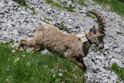
Bouquetin marqué - Julien Heuret - CEN 74 FaunaStudies and Ibexes
This now-protected species almost disappeared from the Alps at the end of the 19th century, mainly as a result of hunting and poaching. Successive reintroductions throughout the Alps have helped to increase population numbers, although the species still remains threatened to this day. In the Haute-Savoie reserves, the ibex are monitored and studied as part of research programmes aimed at monitoring their overall health and improving the population management of the species.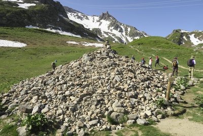
Tumulus du Plan des Dames - Geoffrey Garcel - CEN 74 Plan des Dames mound
This conical mound, which stands around 4m high and has a diameter of 5m, is a burial site. According to a legend dating from the end of the last century, this mound covered the remains of two English ladies who were buried after a terrible storm. It is considered to be cursed, so when passing through the Plan des Dames, it is customary to throw a pebble at the mound to ward off bad luck!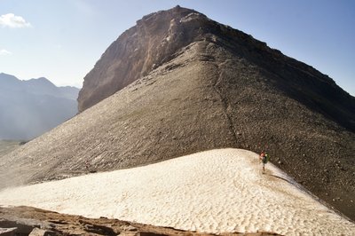
Etage nival - @DahUlm FloraSnow line
This alternate route via the Col du Four gives us a good opportunity to cross the snow line. On the way up to the Col du Four, you might have noticed that the vegetation is becoming increasingly patchy. The first permanent snow line is around 2700m above ground, at the Col du Four, which marks the area where snow can be seen year-round. Although the vegetation is sparser, it still can be seen: mostly moss and lichen and also other plants such as androsaces, saxifragas and glacier buttercups (visible during the climb). The flora finds shelter from the wind and cold in the crevices of the rocks; some plants grow in the form of a cushion.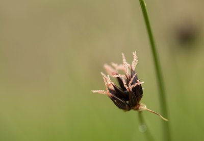
Jonc arctique - Geoffrey Garcel - CEN 74 FloraThe Arctic Rush
As its name suggests, this plant species is found in mild climates in the Northern Hemisphere, but also in the Arctic and in the Alps! It can be recognised by the total absence of leaves and the sparse, blackish flowers in the upper third of the stem. It is a protected species in the Auvergne-Rhône-Alpes region. It is prohibited to pick or otherwise harm this species. It is particularly characteristic of certain alpine environments such as meadows and river banks.
Description
From the Notre-Dame de la Gorge car park in Les Contamines-Montjoie: Cross the footbridge over the stream to join the itinerary. Stay on the main route which goes upstream on your right Stay on the Grande Route and take the Roman road that rises in front of you Stay on the itinerary and cross the "Pont romain" (Roman bridge) At the crossroads, take the left-hand path towards "Col du bonhomme". At the crossroads, turn left towards "Col du bonhomme". At the Col du Bonhomme, take the footpath on the left which climbs towards the Col des Fours. At the crossroads, turn left towards "Col des fours". Continue along the path that rises on your left towards the "Tête Nord des Fours". You have now arrived. The return journey takes the same route.
- Departure : Parking « Notre Dame de la Gorge », Les Contamines-Montjoie
- Arrival : Parking Notre Dame de la Gorge, les Contamines-Montjoie
- Towns crossed : Les Contamines-Montjoie
Altimetric profile
Sensitive areas
Along your trek, you will go through sensitive areas related to the presence of a specific species or environment. In these areas, an appropriate behaviour allows to contribute to their preservation. For detailed information, specific forms are accessible for each area.
- Impacted practices:
- Aerial, , Land, Vertical
- Contact:
- Asters - Conservatoire d'espaces naturels de Haute-Savoie
contact@cen-haute-savoie.org
Black grouse - winter
- Impacted practices:
- , Land
- Sensitivity periods:
- JanFebMarAprDec
- Contact:
Black grouse - winter
- Impacted practices:
- , Land
- Sensitivity periods:
- JanFebMarAprDec
- Contact:
Recommandations
Always exercise caution and plan ahead when hiking. Asters, CEN 74 cannot be held responsible for any accident or incident that may occur on this trail.
Transport
Bus shuttle service from the village centre of Contamines-Montjoie (late June to early September).
Access and parking
Go to Les Contamines-Montjoie (74170). Drive through the village and stay on the Route de Notre Dame de la Gorge (D902) for 2 kilometres until the road ends at the large Notre Dame de la Gorge car park on your right.
Parking :
Parking Notre Dame de la Gorge
Report a problem or an error
If you have found an error on this page or if you have noticed any problems during your hike, please report them to us here:
